Most sailors find entering a new harbor adventurous, and it is. However, most of us also find it, at best, a jaw clamper. Especially at night. And if the weather is terrible, it can equate to a kidney stone. However, good charts, careful piloting, and a GPS receiver will bring you safely into the harbor.
It beats how it was done in 1609 by the intrepid Englishman, Henry Hudson, who for three weeks had to feel his way in the shallow-draft Half Moon to explore the river he claimed for the Dutch (he was sailing for the Dutch East India Company).
But after you get into the harbor, where’s the designated anchorage or marina? Where do you buy fuel? Where’s the dinghy dock? And how about the hula dancers? The answers aren’t in your GPS or chart plotter.
What you need is a cruising guide, and if you had one, you’d have enjoyed reading it the night before and fortifying yourself with facts, figures, and just the right array of local knowledge wherewith to astound and gratify your crew—thus possibly saving yourself the fate of Henry Hudson, who was abandoned at sea by a mutinous crew in 1611.
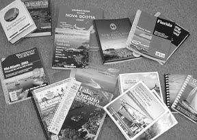
A good cruising guide is worth its weight in gold. A lousy one is a waste of money, and sometimes even dangerous. To help you get the most of your cruising kitty dollar, we collected as many guides as possible covering coastal US waters (not the Virgin Islands and other more faraway places, though to be sure, there are cruising guides to just about every sailable area of the world, including the oceans proper). We’ve used many of these books ourselves.
Like chart kits (reviewed in the May 15 issue), cruising guides have popped up in ever-increasing numbers in the last two or three decades, and there’s enough cross-over in material between the two types to make the distinction fuzzy in many cases.
Once that distinction is made, however, you could say that there are two approaches to the coastal guide. The first is the annually updated, advertising-supported guide written by a flotilla of hired guns and compiled and edited by the publishers’ expert minions. What such books give up in terms of personality and continuity of narrative, they make up for in up-to-the-year information, including harbor changes and those wrought by Mother Nature as well as who’s selling what at which marina.
The second major class is the niche guide, written, usually, by an individual or cruising couple and published either by a conventional commercial publisher, or self-published (by what is known generically as a “vanity press,” which means that you pay a printer to do up your book, and you sell it). What this type of guide lacks in up-to-date harbor information, it often makes up for with anecdotal information on history, flora and fauna, and where, in Little Current, Ontario, in the North Channel, you can buy a home-made blueberry pie. These are almost always labors of love, with little chance of making much of a buck, and usually project personal styles that make them eminently readable.
It’s up to you: Do you want a lot of information, including commercial stuff that is frequently valuable (like restaurants, local diesel repair facilities, laundromats, etc.) or do you enjoy local history, whimsy, and the sights ashore? Both types are valuable, but your investment—in money and bookshelf space—is bound to increase accordingly.
Let’s take a look at coastal cruising guides, beginning in New England but not ignoring the southern, western, and thalassic waters.
In the Beginning…
In 1937, Robert F. Duncan and Fessenden Blanchard wrote the first edition of A Cruising Guide to the New England Coast. Long considered the one indispensable guide, it now displays as authors Duncan’s grandson, Robert C.; his great grandson, Roger S. plus W. Wallace Fenn and his son, Paul W. Fenn, currently head of Jeanneau America.
With over 800 pages, it once was $30, but now sells for $50. The publisher, once Dodd, Mead & Co., then G.P. Putnam, is now W.W. Norton & Co. The book is thorough, textually covering everything from the coast of New Brunswick, down around and up Henry Hudson’s river.
Now…Roger F. Duncan, son of Robert F., father of Robert C., grandfather of Roger S., and co-author, with John Ware (Blanchard’s son-in-law), of many editions of the guide, is also the founding editor of Practical Sailor. We hope it will not sound ungratious if we say that for practical purposes, there are better databases and formats (layouts) to choose from among today’s guides. There is very good information in the book—including some fine, detailed history—but over the years we’ve found ourselves using the book only a little for piloting and decision-making. It has a goodly number of high-altitude black and white aerials, fewer charts, and much text that bears linguistic semblance to a dry martini, best read while sipping one at anchor.
This 66-year-old book is in its 12th edition, including a big overhaul in 2002, and the story of Captain Phillips and the schooner Little Mary, quoted in successive editions of the book (starting on page 361 of the current edition), is worth the entire price of admission.
A newer book of the same genre—meaning heavy on copy, light on the pictures—is John E. McKelvy, Jr.’s Cruising Guide to the Nova Scotia Coast. Carrying the imprimaturs of both the staid Cruising Club of America and the Royal Nova Scotia Yacht Squadron, the ring-binder book is the primary guide for the Canadian Maritimes. Rather like the Great Lakes Cruising Club guides (which are superb), the McKelvy book is updated biennially, with contributions from other sailors. Now in a third edition (not counting updates) the book sells for $45. It’s carried by The Armchair Sailor bookstore and by Landfall Navigation. See contact information at the end of this article.
Another New England guide is the Atlantic Cruising Club’s Guide to New England Marinas, compiled, written and edited by Elizabeth and Richard Smith, and published by Jerawyn Publishing. Now in its seventh edition, the perfect-bound, 8.5″ x 11″ book divides New England from Bar Harbor, ME to Block Island, RI into 12 sub-regions and includes 230 “Marina Reports” in a straightforward, standard format (one marina per page) with no advertising. It comes with a CD-ROM that includes a searchable database of all the marina reports, plus “up to nine full-color photographs of each facility.” The whole package costs $25, and the Smiths, via their Atlantic Cruising Club, have plans to increase their coverage southward by leaps. This is a very good effort for a very good price. We’ll look forward to the expanded coastal coverage.
The Big Boys
Ten years after Duncan the First, there came the first edition of the Waterway Guide (Northern Edition, 422 8.5″ x 11″ pages, once $30, now $37 (which is a modest price increase over the years). The company has changed hands at least nine times since 1947 and did so again last September, moving for the sixth time (from Atlanta, GA, to Annapolis, MD, where it was in the first place). Walter Cronkite’s “most trusted man in America” face appeared in 1992 on one whole year’s set of these regional guides.
Waterway Guide was the first, to our knowledge, to give marina listings for each major harbor. A handy grid format is used, indicating such things as number of slips, dockside depth, fuel, electrical service, availability of repairs and pump-out stations, etc., all keyed to charts to make them easy to find.
Cruising directions are far briefer than in the above-mentioned Duncan book, but the basics are there, enough to get you from A to B, even if you don’t get the anecdotes and historical tidbits that make the Duncan work a good readin’ book. Instead, the Waterway Guide serves up heap of advertising.
The Waterway Guides come in three flavors—the Northern edition (Canadian border to Delaware Bay); Mid-Atlantic (the Chesapeake Bay to the Florida border), and the Southern edition (Florida to the Mexican border). The last is a sort of wrap-around southeastern U.S., including the Bahamas, that goes all the way to Brownsville, Texas. The Mid-Atlantic and Southern books cover the ICW down to and through Florida. They are good buys.
Quite a few years after the first Waterway Guide came out, the choice became complicated by the entry of Embassy Marine Publishing’s Complete Boating Guides. The first editions were Rhode Island & Massachusetts (434 8.5″ x 11″ pages, and Long Island Sound (425 8.5″ x 11″ pages, now $45, each.
The Embassy books, loaded with nautical information (and advertising) are excellent, with many harbor charts reproduced in full color. Marina listings and cruising directions were slightly cleaner and more attractive than those in the Waterway Guide.
In addition, the Embassy books had a spiral binding, while the Waterway guides were for years what is called “perfect bound.” Although far more expensive, a spiral binding allows the open book to lie flat.
One shortcoming of the Embassy books was that the popular New England version did not include Maine, whose waters are very popular. Embassy attempted to remedy the situation by doing a separate Maine edition, which we note is for sale this year at a greatly discounted price. (It also has now an Atlantic Coast, Maine to Florida, edition.)
After its initial offering was well accepted, Embassy expanded with additional editions and became so successful that Maptech (the electronic cartography company often mentioned in these pages) bought the whole line, which includes, besides the above two, Atlantic Coast, Maine to Florida ($45); Maine Coast ($20); Chesapeake Bay ($20); Florida ($45); The Bahamas ($45), and the New York State Canal System ($25).
Facing fierce competition from Embassy, Jack Dozier, Waterway Guides’ new owner, set in motion a complete overhaul of the Waterway Guide books, including converting to the spiral binding. (Dozier owns a couple of Rappahannock River marinas, down there where Washington put it to Cornwallis.)
The Maptech people may not like it, but the 2003 editions of Dozier’s Waterway Guides strongly resemble the Embassy books, even to the back-cover fold-in page marker. It was a format worth imitating, helpful to sailors using the books, although it makes the choice between the two impossible on any other than detailed personal preference.
Southward
If anyone has a well-deserved lock on Florida, it’s Frank Papy, with his Cruising Guide to the Florida Keys (including a Florida West Coast supplement), now in a revised 11th edition. Charterers in the area will be familiar with Papy’s book, because it’s provided on board charter boats by companies like Florida Yacht Charters and Sales and The Moorings. Text blocks are short and to the point, and accompanied by excellent aerial photos and harbor and approach charts. Trim size is 8.5″ x 5.5″, with a plastic comb binding.
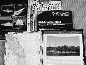
Papy doesn’t try to cover every harbor and inlet—he concentrates on the ones that are reasonably simple and safe to get into with a moderate draft. (This may be one reason he’s in favor with the charter companies.) The book is a true bargain at $20.
We should note that although his Florida Keys book is businesslike, Capt. Papy has a considerable flair for story and anecdote, some of which he recently published in a book called Impressions, Ideas, Deeds.
The publishers of Papy’s Florida Keys book, Cruising Guide Publications, produce a slew of other books covering Florida and the Caribbean.
Another recent book, published by the Dodge family, is called Inlet ChartBook: Southeastern United States (White Sound Press). Anyone who’s had difficulty “running the bar” will want this $20 book, which covers 32 important “non-commercial” inlets from the Chesapeake Bay to Miami. A non-commercial inlet is one that the NOAA deems not for big ships, and thus is “grayed out” and cryptically dismissed by “Local knowledge is needed,” or, even nastier, “Shoaling reported.” The book includes beautiful modified NOAA charts and aerial photos, made understandable by water color or taken when the wind was creating whitecaps that clearly show where not to go. If you think you’re really good at crossing the bar, you might try St. Helena Sound in South Carolina. Most cruising guides blow right by it.
The Dodges also publish The Cruising Guide to Abaco Bahamas, through White Sound Press, also for $20.
The West Coast
There’s no sweeping equivalent Embassy/Waterway Guide competition on the West Coast, which runs for considerable stretches without a single decent harbor to put into. Consequently, the guide books—and there are many, many of them—cover much more specific locales.
One of several exceptions to the above generalization are the four Pacific Boating Almanacs. All $30, the editions are The Pacific Northwest & Alaska; The Pacific Northwest; Northern California and the Delta, and Southern California & Mexico.
The Pacific Almanac books are printed and sold by Prostar Publishing of Annapolis, MD and Culver City, CA.
These almanacs are 6″ x 9″, soft-covered books that contain a lot of government information about tide and tidal currents; coastal piloting and navigation; weather; first aid, etc. There are brief harbor descriptions in prose and there are almost no maps or photos. They are not for gunkholers. There’s only a little advertising, in the front and back.
Prostar also publishes four Atlantic almanacs, a Gulf of Mexico almanac, and cruising guides to California’s Channel Islands, the Sea of Cortez, and the Colorado River.
Another exception is The Cruising Guide to Central and Southern California ($30), by Brian Fagan, an author/sailor known widely on the West Coast. His book, which came out in 2001, is a combination of three earlier guides (two published, one planned) for waters south of San Francisco, which were not in those earlier times much frequented by yachts. The area is now a well-sailed thoroughfare. Fagan’s publisher this time is International Marine (which is owned by McGraw- Hill), the nation’s most prominent nautical book publisher.
The 372-page Fagan book, instead of being the mass of merely practical information often packed in a cruising guide, resembles the Duncan book. On page three Fagan says, “The mix of sailing directions, pilotage, and general reading in these pages…” It is good reading indeed, but the format takes getting used to if you’re interested in grabbing quick information when entering a strange harbor during one of those California fogs you could serve for lunch with oyster crackers dipped in guacamole.
A nice, practical feature of the book is Fagan’s use of arrows superimposed on many of the black and white photos, showing anchorages and features to be aware of, with captions that say what you’re looking at: “Smuggler’s Cove from SE, distant 2 miles. The best anchorage lies off the olive grove on the hillside behind the bay.”
Seabreeze Ltd., a nautical book and chart store in San Diego (619/223-8989) will be a good source of information on other titles available for the West Coast . Ask for Capt. Ann Kinner.
Pacific Northwest
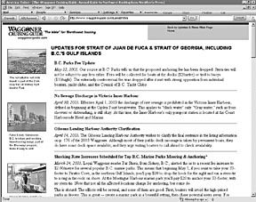
In this area, the outstanding book is the Waggoner Cruising Guide, which purports to be “the bible” for Northwest boating, and probably is. The 318-page 10th anniversary edition costs $17, certainly a Best Buy in a cruising guide. It covers the waters from Olympia, Washington (at the south end of Puget Sound), to Prince Rupert, 30 miles short of the Alaskan border.
This guide (read Bowditch for a fascinating bit about why it’s named Waggoner; look in the index for “Lucas Janszoon Waghenaer”) is the personal project of Robert and Marilynn Hale, who spend 10 weeks each summer hustling around in a diesel powerboat to collect revisions. The big book contains a density of useful information about weather, customs, anchoring, aids to navigation, VHF radio, VTS (vessel traffic service, which is important in these waters), and keeps the anecdotal material to a minimum. The Hales’ restraint in those areas leaves a lot of room for excellent harbor coverage.
One of the best things about the Waggoner Guide isn’t even the book itself, but its website, which showcases Mr. Hale’s wholehearted devotion to his project and the pursuit of cruising in his home region. It has a trove of valuable information for anyone sailing that area, and an interactive flavor that makes visitors almost feel as if they belong to a cruising club. Particularly useful are the online updates on everything from new regulations to changed mooring fees.
Another book covering almost the same ground as Waggoner but somewhat in the Duncan/Fagan vein is Migael Scherer’s A Cruising Guide to Puget Sound ($40). It’s a 288-page hardcover written with charm and published in 1995, which means that it probably needs updating.
Also out-of-date but still being sold is Frieda Van der Ree’s Exploring the Coast by Boat ($20), a little (6″ x 9″) 238-page book that covers Puget Sound, Desolation Sound, and the Discovery Islands. It was published in 1979.
In nautical book stores and chandleries you’ll find more up-to-date guide books for the northwest, like the four-book package by Don Douglas and Reanne Hemingway-Douglas, called Exploring Cruising Guides on Alaska, British Columbia, and the San Juan and Gulf Islands. Covering much the same ground are the several guides done by Don Wolferstan, and Northwest Boat Travel by Phil and Owen Cole. These are all good books, packed with useful information. For the Douglas, Wolferstan and Cole books (and others), call Bluewater Books & Charts (800/942-2583), or check the website (www.bluewaterweb.com). (We’re not pushing this store in particular; there are other nautical bookstores with similar offerings. Many of them are listed at the end of the report on chart kits in the May 15 issue of PS.)
Illustrative of the specialized books for smaller areas is the Cruising Guide to San Francisco, a 253-page book that contains black and white copies of two government charts (#18649 and #18654) printed back-to-back on a single piece of 24″ x 32″ paper. Its authors are Carolyn and Bob Mehaffy, live-aboard magazine writers who know how to do it. After a year of poking into every anchorage and harbor, this team did a Cruising Guide to the Hawaiian Islands, too.
The Mehaffys’ publishers, Matt and Jim Morehouse of Paradise Cay Publications, also make the Cruising Guide to San Diego Bay, by Barbara and Ed Bowler. The Morehouses print a lot of West Coast publications from their office in Arcata, CA.
River Guide
Moving back east and inland now, let’s touch on a new book that attempts to cover all or parts of heartland rivers named Chicago, Calumet, Des Plaines, Illinois, Mississippi, Ohio, Cumberland, and Tennessee. The book, Cruising Guide from Lake Michigan to Kentucky Lake ($29), is one of many published by Pelican Publishing in Gretna, Louisiana. Its author is Rick Rhodes, who also wrote A Cruising Guide to Florida’s Big Bend for the same company. These books, along with the new Cruising the Florida Keys by Claiborne S. Young and Morgan Stinemetz, suffer a bit from poor production quality of many of their photos and chart reproductions, although their hand-drawn charts are good. (We at PS are acutely aware of living in a glass house when it comes to making judgments on these matters.)
Claiborne S. Young’s other books for Pelican include Power Cruising, Cruising Guide to Eastern Florida, Cruising Guide to Western Florida, and Cruising Guide to the North Gulf Coast. His books are quite good, and set the standard for Pelican.
The Great Lakes
For the Great Lakes, there’s nothing to compare with the huge four-volume Great Lakes Cruising Club Port Pilot and Log Book. There’s no advertising, of course, but facilities are listed and sometimes described or recommended. The huge three-ring binders cover like nothing else the 800+ harbors of the “Inland Sea.” It costs $260 to join the Chicago-based GLCC and $160 a year for annual dues and harbor updates. (The entire book is renewed by member contributions about every five years.) Great Lakes cruisers consider it a bargain. Call Mary Faulhaber, the club’s single, full-time employee at 312/431-0904.
Next best, but a lot easier on the wallet, are the full-color Ports ‘o Call cruising guides published by Lakeland Boating (owned by O’Meara Brown Publications) of Evanston, IL, and the Ports Cruising Guides, published by Overleaf Design, Ltd. of Toronto, Ontario. No, these are not the same books. They are the same size, they both have spiral bindings, they cover many of the same areas, but they are undoubtedly competitors.
The five Lakeland Ports ‘o Call guides (Lakes Michigan, Huron, Superior, Erie and Ontario) range in price up to $63 (a complete set for $220), are said to cover the same 800+ harbors as the GLCC books, and get updated about every three years.
The Ports Cruising Guides include Lake Ontario & The Thousand Islands ($38); Georgian Bay, The North Channel & Lake Huron ($35), and The Trent-Severn & Lake Simcoe ($35).
We’ve compared the Lake Ontario efforts of these competitors side by side. The books are priced about the same, and are both packed with information. If there’s a problem, it’s that the information is so densely packed—there’s almost too much. The Lakeland offering has a fold-in cover flap to mark the spot; the Ports books have index tabs protruding. The lists of features included in each guide overlap significantly, and also offer some different things, like local street maps versus golf courses. Without more intimate knowledge of the nitty-gritty accuracy, it’s tricky to make a choice between them.
Conclusions
Mentioned herein is a good-sized fraction of the cruising guides used in the continental United States and Canada, but the topic is too big to address properly in one article. Some of the small-area publications are excellent and provide invaluable local detail; others are adorned with material that is whimsical, overly anecdotal, completely extraneous (bad cartoons, chart sketches simply outlined crudely from government charts, etc.)
However, we won’t criticize even the poorer publications because they are, after all, labors of love. Most are barely commercial ventures at all, and they woudn’t get done unless someone was entranced by and dedicated to a particular patch of water. One of the best-selling cruising guides sold in 2002 way less than 10,000 copies. Even at the full cover price (rarely realized in these days of discounting), it generated only about $125,000. The gross does not count advertising revenue, without which the publisher couldn’t begin to pay the bills…to authors, printers, handlers, dealers, office space, staff, etc.
We’d prefer, instead, to hear something from readers who are attached to particular guides. Let us know which, and why. We’ll follow up with a Riprap later in the year.
In order to prime the pump, here’s a note we received from a reader, Warren Miller, after we published the chart kit article:
“I read in your May 15 issue that you will soon review cruising guides. Please review Skipper Bob’s Anchoring Guide to the Intracoastal Waterway. I have used it for several years now and it is wonderful. It is a concise listing of anchorages from up the Hudson River to the Florida Keys that is (I have heard) a compilation of US Power Squadron recommendations. I have lived in Melbourne, FL for almost 60 years, and before I bought the copy that I found in Beaufort, SC, I checked to see what was said about Mel- bourne. They listed all ten of the anchorages that I know of in the area. I have anchored in dozens of their anchorages in several states, and they have been easy to find and exactly as described. For those of us who dislike marinas, the book is a godsend. A good review might make it better known, and hence better stocked.”
Thanks, Mr. Miller. We can consider that review done. See contact information for Skipper Bob below.
Keep the picks coming. Meanwhile, fair cruising.
Contacts
• The Armchair Sailor, 800/942-2583, www.seabooks.com
• Atlantic Cruising Club, 888/967-0994, www.atlanticcruisingclub.com
• Bluewater Books and Charts, 800/942-2583, www.bluewaterweb.com
• Cruising Guide Publications, 800/330-9542, www.cruisingguides.com
• Embassy Guides, 888/839-5551, www.maptech.com
• International Marine, 207/236-4837, www.internationalmarine.com
• Landfall Navigation, 800/941-2219 www.landfallnavigation.com
• Paradise Cay Publications, 800/736-4509, www.paracay.com
• Pelican Publishing, 504/358-1175, www.pelicanpub.com
• Ports o’ Call, Lakeland Boating, 800/589-9491, www.lakelandboating.com
• Ports Cruising Guides, Overleaf Design, www.portsbooks.com
• Prostar Publications, 800/481-6277, www.prostarpublications.com
• Seabreeze Ltd., San Diego, CA, 619/223-8989
• Skipper Bob, 724/775-5892, http://home.att.net/~skipperbob/index.htm
• Waggoner Cruising Guide, 800/733-5330, www.waggonerguide.com
• Waterway Guides, 800/233-3359, www.waterwayguide.com
• White Sound Press, 386/423-7880, www.wspress.com
• W.W. Norton, 212/354-5500, www.wwnorton.com


