384
It has been two years since we last looked at small-screen plotter-sounders, and at the pace marine electronics is changing, it might as well have been two decades. Since then, there have been some significant changes among the major players in this market: Raymarine has been bought by night-vision specialists FLIR; Garmin recalled and then-reintroduced its G2 Vision charts; and Humminbird and Lowrance have unveiled big improvements to their side-scanning technology. Processor speeds are up, chart chip sizes are down, and as a result, today’s 5-inch plotter-sounders are almost as powerful (and in some cases more powerful) than the big-screen multi-function device of 2009. The turbo-boosted sounding technology has been one of the biggest transformations in this field, making it difficult for smaller players to keep a toehold in the small-screen plotter-sounder market.
What We Tested
Because of the versatility and power of small-screen plotter-sounders today, Practical Sailor took a two-part approach to this comparison. This article will focus on the functions that are most critical in a chartplotter, the navigation capabilities and networking with other onboard electronics. Next month, we will take a more detailed look at the sounder capabilities. For a complete discussion of the testing procedures, check out “How We Tested,” on page 19.
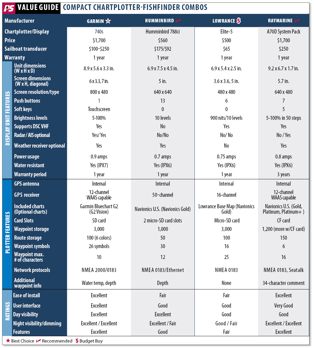
For this comparison, we looked at four different units priced from $1,500 to $700. As the price span suggests, there was a disparity in the features and performance among the units, but in terms of the essential GPS-based functions, the distinctions were less significant. Screen sizes and networking capabilities split the group into two ranks. The “big boys” in this test were the Raymarine A70D and the Garmin 740S. Both units had bigger screens, both could handle the latest 3D charts, and both were designed to network easily with wind instruments and autopilots. The Garmin, in fact, had plug-and-play radar capabilities. The “little guys” in our comparison were the Lowrance Elite-5 and the Humminbird 798si. Both had 5-inch diagonal screens and were geared more toward fishermen than sailors. However, when you look at things such as screen brightness, user interface, and ease of installation, the differences between these two tiers of plotter-sounders was less apparent. When it comes to compact plotter-sounders, you can still get everything you need for less than $1,000. You just might not get everything you want.
523
Garmin 740S
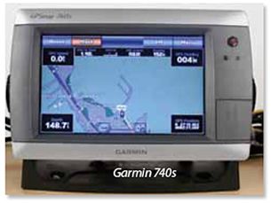
The most expensive product in our test was also the most versatile and potentially the most powerful. The touchscreen Garmin 740s had the biggest screen in our group and was the only one that would interface with radar, allowing you to display a separate radar picture, and/or radar overlay on a chart. The unit can be paired with its GMR series radar, which adds about $850 to the price.
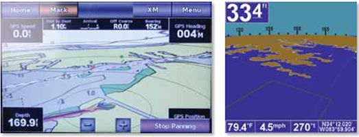
We tested the 740s with the standard, pre-loaded BlueChart G2 map data for all U.S. coastal areas, including Alaska and Hawaii, plus Explorer Charts for the Bahamas. The basic charts allow an angled bird’s eye view. The Lowrance Elite-5 also has this feature, but the Garmin 740s does it much faster and better. Upgrading to the G2 Vision charts enables 3D perspectives that Garmin calls MarinerEye and FishEye (a 3D view of the below-the-waterline seascape based on chart data), and satellite imagery. The chart upgrade also enables what Garmin calls “Auto Guidance” to create a route that avoids obstacles based on GPS data—a handy feature, but one we’d use with conservative user-set parameters (ample distance from obstacles) and due caution. This high-tech visual interface, coupled with the touchscreen, gives the Garmin a huge advantage in the “wow” factor category over the other units in this comparison.
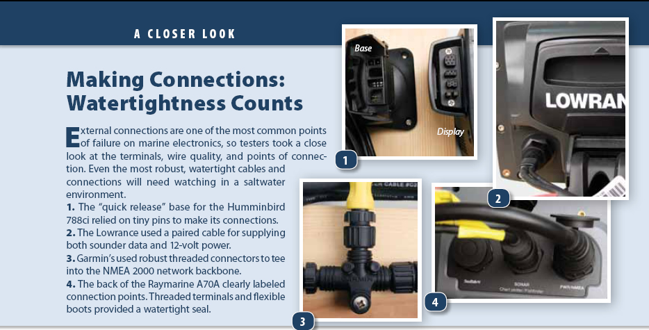
Installation is fairly straightforward, with watertight sockets for data and power, radar, NMEA 2000 networking, and an external antenna. Mounting and connectors are robust, although the bracket does not swivel. A flush-mount kit is an extra $16.
523
The touchscreen interface is very intuitive, and allows a great deal of flexibility by bringing multiple menu choices right to your fingertips. The all-important “Back” option appears when you need it. The big pay-off comes when panning. Just swipe the screen to move the chart in any direction. In the “bird’s eye” view, you can spin around 360 degrees and more clearly visualize landmarks used for traditional compass-and-rule piloting. The Garmin’s panning ability, a key attribute in small-screen units—was heads-and-shoulders above the other units in this test. Exploring menus was a breeze.
The touchscreen, although tough and watertight, has downsides: the capacitive touchscreen technology will not work with gloves; you lose the tactile feel of pushing a button; and oil and grease from fingers tend to smear the screen. As user-friendly as the touchscreen is, some find track-pads, buttons, and rotary dials easier for some functions, particularly in rough weather.
Feature wise, the Garmin covers all the basics, and then some. One of the first things that caught the testers’ attention was the built-in light sensor that automatically adjusted screen brightness to ambient conditions. Manual dimming was also easily accessible by tapping the power button. Zoom options are at the bottom of most screens. The Garmin has outstanding networking capabilities for this price point. It can display Digital Selective Calling (DSC) VHF information as well as Automatic Identification System (AIS) data. The optional GXM 51 satellite receiver lets you use XM WX satellite weather service (about $50 per month). The 740s also matches up with Garmin’s new GDL 40 Cellular Marine Weather Receiver (about $300), which provides weather via GSM cellular network for a fee of $5 per day. It was the only unit in our test that easily interfaced with NMEA 2000 protocol, so if you like the idea of seeing fluid levels or engine data (more relevant to new powerboats), this is the plotter-sounder to look at.
305
The plotter’s MOB capability offers a good example of how NMEA 2000-compatiblity can turbo-boost functions that involve multiple navigation or communication instruments. If the 740s is networked with one of Garmin’s NMEA 2000-friendly VHF radios with DSC (starting at about $400), initiating the plotter’s MOB function will automatically prompt the VHF to show the “Distress Call” page for making a man-overboard DSC distress call. If you have a Garmin autopilot connected to the network, your chartplotter prompts you to start a Williamson’s turn, a gradual turn that brings a boat under power safely back to a point it has previously passed through. Our only complaint, is that the MOB function requires three separate inputs.
While the sounder lacks some of the specialized features found in the Lowrance or the Humminbird, such as record and playback, it covers the typical sailor’s needs handily. We will look at these in greater detail next month.
The Garmin is the priciest unit we looked at, and upgrading to a transducer with a faring block adds $250. An external antenna, the GA 30 GPS, goes for $70, bringing a 7-inch plotter close to the $1,750 mark. This is a lot to pay for a small display, but with its NMEA 2000 interface capabilities—radar foremost among the most powerful add-ons—it packs almost the same punch as top-of-the-line units.
Bottom line: For the sailor who wants it all, including radar, in one compact multifunction display, the 740s is hard to pass up. It is robust with a dead simple interface and a superbright display, and its optional radar gives it an edge over the Raymarine A70D. For non-radar users, the deciding factor will be which chart system you like best.
283
Humminbird 788ci
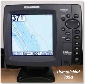
The Humminbird 788ci is a middle-range unit in Humminbird’s 700 series of plotter-sounders, with the most advanced unit being the 798ci SI with side-imaging technology, a feature we will look at next month. Like the Lowrance Elite-5, the 788ci unit emphasizes its sophisticated fishfinding functions. If ice-fishing is your off-season hobby, this is the unit to look at. Testers noted that the Humminbird’s sharp, bright screen was one of the better products when it came to handling polarized sunglasses, allowing better visibility from angles up to 45 degrees.
The swivel-head mount (also found in the Lowrance) allows you to rotate the unit on a horizontal plane, a bonus when steering from one side of the cockpit. The unit’s quick-disconnect mount makes it easy to remove the unit from its mount, but leaves tiny pins exposed to the elements. If you sail in salt water, you are better off leaving the display in place, or making sure the connectors are sealed or protected with an anti-corrosion spray when you remove the display from the mount.
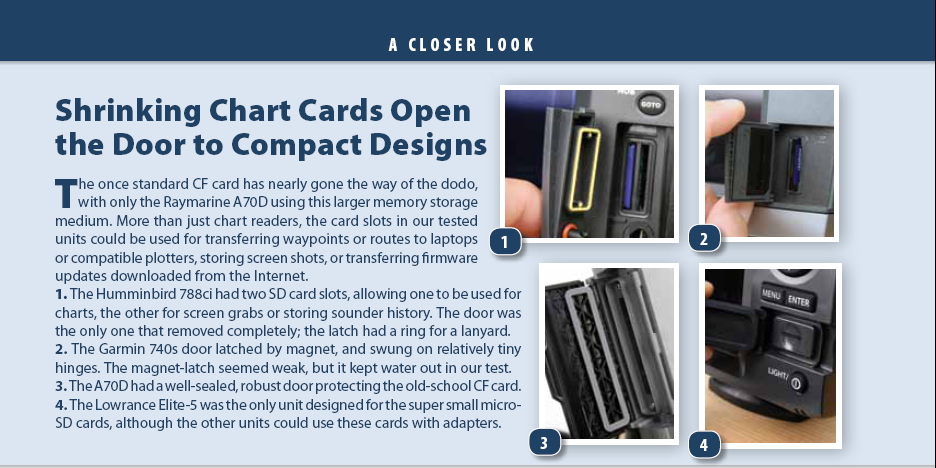
The Humminbird 788ci came with Unimap for North America, but we also tested it with the optional Navionics Gold charts, which we recommend. Navionics Platinum or Platinum+ charts are not supported. The unit has two SD card slots allowing access to two different chart sources at once. One or both cards also can be used to store screenshots or record active sonar video.
The Humminbird has some fairly advanced interfacing options, including a high-speed Ethernet connection that allows you to share sonar, GPS, and waypoint data between compatible units. It also has a dedicated COM port for interfacing with a DSC-equipped VHF radio. However, configuring the network requires some tech savvy or support from Humminbird’s tech line. In terms of manuals and other documentation, the Humminbird was a notch behind Lowrance, and a big step below Garmin and Raymarine. The sophisticated sounding capability is off the charts, but you’ll likely have to rely on tech support to master all its potential. We’ll look closer at these functions next month.
The Humminbird’s interface rated a below the Raymarine, but better than the Lowrance. The “Exit” key kept us out of trouble when we went diving into menus. Like the Lowrance Elite-5 and Raymarine A70D, the Humminbird 788ci relies on a trackpad to control the cursor or make menu selections. Creating and navigating to a waypoint using the GoTo button was easy, but route creation could only be carried out from the Route menu. In addition to its “View” button, the Humminbird allowed the user to customize three pre-set views. This lets you quickly jump to your three favorite display pictures, rather than cycling through a mind-numbing array of options to get to the view you want.
One disappointment was the somewhat ambiguous MOB function. To activate the MOB navigation mode, you press and hold the GoTo button for 1.5 seconds, but only ambiguous “MOB” stamped on the control head near the GoTo button indicates this function. You must dig into the manual or use your noggin to figure that one out. However, when the MOB function is activated, the Humminbird is a winner. It automates several functions to aid in an MOB recovery: The view switches to chart view, displaying elapsed time since the MOB function was activated; a course line to the MOB location is automatically generated, indicating the direction to steer; and the display shows the MOB lat/lon position in bold letters.
Daylight screen visibility was exceptional for such a small unit, and one of the more interesting features was a Bird’s Eye View that shifts the perspective to an oblique angle so that you can “see” farther in any direction than you might see in a static overhead view. Like the Lowrance Elite-5, the screen did not dim as much as we would have liked, even with the night palette, but its brilliantly lit daytime screen rated higher than the big-screen Garmin 740s.
The Humminbird will network with a variety of Humminbird devices, including XM WX weather and the digital “WeatherSense” barometer that displays 12 hours of barometric trend data. It is compatible with Humminbird’s external 50-channel GPS/WAAS antenna, which Humminbird claims will deliver faster, more accurate fixes (within 8 feet). It will also work with its QuadraBeam Plus Transducer, which covers a wider area to the left and right of the boat, but this will require a shoot-through-the-hull installation. Humminbird offers two through-hull transducers that will work on most sailboats (Model # XTH 9 20), in plastic ($95) or in bronze ($175). Interfacing with an autopilot requires the $24 Handheld GPS Connection kit, essentially a Y-cable for interfacing with NMEA 0183 devices.
Bottom line: This unit will warm the heart of a Minnesota sailor who wants a sophisticated fishfinder for the winter and a brilliant plotter for his summer sailing. Unless fishfinding is a priority, saltwater sailors should migrate to a more robust model from Raymarine or Garmin. The route-building interface could be improved.
253
Lowrance Elite-5
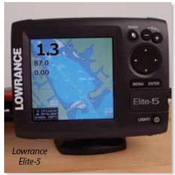
Lowrance built its name around its sonar technology, so it is no surprise that the Elite-5 emphasizes fish-finding abilities. While the GPS chartplotter delivers all the key features a small-boat sailor might need, its sounder capabilities are what set it apart. One of the Elite-5’s more unique features, for example, is the ability to track back through multiple pages of sounder history, useful when trying to relocate a bottom feature that held some fish—or good holding ground.
Aimed primarily at the small-boat angler, the Elite-5 is the least expensive unit in our test, but it boasts many advanced features. The basic model comes with built-in Lowrance coastal maps for the U.S, but sailors venturing farther afield will want to upgrade to the compatible Navionics Gold charts. For a modest premium, Lowrance sells an Elite-5 Gold package with a 2GB micro-SD card covering the U.S. and Canada, including the Great Lakes. Separately, the chart goes for about $200.
The Elite-5 won’t work with the more graphics-intensive Platinum charts, but the Gold Series, which garnered a Practical Sailor Best Choice in 2006, is still a perfect tool for a chartplotter in this size. In our opinion, investing in 3D images for a 7-inch screen is a bit like watching “Avatar” on your smart phone—missing the point.
The unit comes with a 500-watt dual frequency 83kHz/200kHz transom-mount combination transducer/temperature sensor. The only other option for this particular model is a shoot-through-the-hull transducer ($65), installed on the inside of the hull so that it can penetrate solid fiberglass. A shoot-through transducer won’t work through cored hulls, wood, or metal. Cored hulls will usually have some solid laminate near the keel, but you’ll want to consult your hull-maker first to check. You will want to test any shoot-through installation with a temporary setup before gluing or bonding it to the inside of the hull.
The Lowrance Elite-5’s small-boat focus has limited networking ability compared to the pricier units in our comparison, but it works fine for smaller boats. To connect with NMEA 0183 devices such as an autopilot or VHF (for DSC calls), you’ll need an NMEA 0183 adapter, which costs another $22. An external GPS antenna adds another $80.
The user interface is straightforward with separate buttons for Pages, Menu, Zoom In, Zoom Out, Enter, and a Trackpad to control the cursor or make selections. It lacks the Exit, Cancel, or Back choice of the other units, relying instead on the Menu button to re-orient lost users.
The Pages button cycles through four options: Steer, Sonar, Chart/Sonar, and Chart. On each page, a dedicated Menu function lets users carry out typical tasks associated with that function. The menu on the Chart page, for example, offers various waypoint or route-building options. Route building is more unwieldy than either the Raymarine or Garmin, but easier than the Humminbird. It lets you to enter new waypoints at any point in an existing route from the chart without much trouble.
To activate the MOB function, you press the two zoom keys simultaneously, which brings you to the Steer page, effectively a cluster of navigation data boxes displaying a digital compass, along with navigation data such as distance, course, and bearing to the man overboard (or waypoint, in normal navigation mode).
Although you can transfer waypoints and routes via the SD card there is no option to save screen grabs.
Screen visibility was excellent in bright daylight, but when it came to dimming down, the Elite-5 still cast lots of ambient light that could inhibit night vision. This was the only unit in our test that would not link with a satellite weather service.
Bottom line: Our lowest price unit, the Elite-5 makes for a good entry-level plotter-sounder. Interface and limited transducer options hold it back.
308
Raymarine A70D
The Raymarine A70D is the big brother of the A50D that Practical Sailor reviewed in June 2009, and it shares many of the same advanced features. Raymarine has just introduced its replacement, the new e7, a 7-inch multi-function display with both a touchscreen and a rotary-button backup. Production of the A70D is scheduled to end in December, and Raymarine is offering $400 rebates through November 30. Watch for close-out sales.
The A-Series units (including A50D, A57D, and A70D) do not have a SeaTalk connection on them, though they do have the newer SeaTalkng connection, Raymarine’s newest data networking protocol that also mixes with NMEA2000 devices. If you are interfacing to Raymarine’s newer generation ST70 or ST70+ instruments or X-Series autopilot corepacks (X-5, X-10, X-30) the A70D is ready to connect. If you need to interface the A70D to older instruments like ST30, ST40, ST50 or ST60 series instruments,you will need to add the PC/SeaTalk/NMEA interface box (E85001, MSRP: $159).
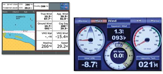
Like the Garmin 740s, the Raymarine A70D can be integrated with DSC VHF radios, AIS Class A and Class B systems, and masthead sailing instruments. The A70D and the Garmin 740s are the only units we tested that offer pre-set “sailing” pages that display wind speed and direction data (on boats equipped with the optional wind sensors). For radar overlays, you need to step up to the higher-priced units. As with Garmin 740s, the A70 offers 3D chart views and geo-referenced satellite pictures, although this will require paying extra for the Raymarine Platinum or Platinum + series charts (about $200 per card). This upgrade also enables live animation of tide data and real-time tidal current vectors. Although the A70 is designed to match the older, bigger CF cards, it comes with an adapter to accept the latest Micro-SD cards.
Accessories aren’t cheap. Sirius weather imagery requires a $600 antenna and a monthly subscription, the $270 sailboat transducer is one of the most expensive in our test, and the Raystar external antenna lists for $400.
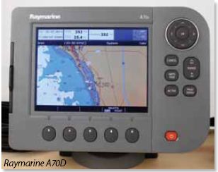
The Raymarine’s combination of five soft keys and six dedicated buttons make for easy interface, once you become accustomed to the soft-key routine. The small size of the type/images on the soft-key options made navigating menus tedious compared to the Garmin 740s. These were sometimes hard to read in bright light. Some functions, like the ruler—which allows you to measure distances and courses to hypothetical destinations on the chart—are handy tools, but its lack of a keyboard (a shortcoming in every unit except the Garmin) makes naming waypoints a chore.
Overall, our testers gave the A70D high marks for the most-used features of route building and moving and setting waypoints, although the sluggish panning held it back compared to the Garmin in these functions when carried out in chart mode. It also struck testers that the anchor alarm’s “electronic fence” parameters are measured in 1/100th of a mile, rather than more user-friendly meters, yards, or feet.
The clearly-labeled man-overboard function, which activates by pressing and holding a dedicated MOB button for 3 seconds, also got high marks. The A70 will integrate with Raymarine’s Lifetag system of man-overboard alarms, reviewed in May 2008.
The A70D comes with five pre-configured pages for data: Navigation, Waypoint, Route, Fishing, and Sailing. The Sailing screen is geared more toward racing, including apparent wind, true wind and VMG wind, but all data pages can be customized to show up to 12 pieces of data.
In the depth sounder mode, your waypoint shows as a vertical line, so you can see your bottom type depth at your waypoint—a convenient feature for anchoring. Moving a waypoint is easy using the Move waypoint soft key. Editing routes to insert new waypoints works in a similar way.
Although not the brightest unit, the Raymarine’s screen visibility rated well. Testers experienced some screen blackout when viewing the screen through polarized glasses, to about the same degree as they did with the Garmin 740s. Its dedicated night screen dimmed down to the lowest usable level of all the units, excellent for preserving night vision. One convenient screen feature that appealed to the tester’s analog sensibilities was the compass bar (also found in the Lowrance), which simulates a conventional compass at the top of the chart view.
Bottom line: Raymarine has stayed consistent with its mission here, focusing on the essentials like user interface and screen visibility. Although it will soon be eclipsed by the Raymarine e7, it still offers a lot of bang for the buck. The Navionics Silver platform costs more, and accessories aren’t cheap, but we like the interface and flexibility. Raymarine’s free, 3-year extended warranty, is also a big plus. It gets our Recommended rating.
Conclusion
Our test criteria focused on the fundamental chartplotter functions. Except in two cases—Humminbird’s vulnerable Quick Connect connectors and the Lowrance’s ambiguous MOB function—all of them met or exceeded our minimum criteria. We will be taking a closer look at sounder functions next month.
The main fork in the road is charts. All but the Garmin 740s will take Navionics Gold charts, and these remain our favorite for two-dimensional coastal charts for most U.S. coastal areas. If you want 3-D and satellite views, the choice boils down to the Raymarine (Navionic Platinum or Platinum +) or the Garmin 740s (G2 Vision), and each 3D chart package has its pros and cons. We recommend that a buyer take some time to test-drive these charts before committing to expensive hardware. While the satellite views are handy, the 3-D imagery is nice but unnecessary. At some point, too much information is not a good thing.
At the high end, the Garmin 740s nudges ahead for its affordable radar interface. The A70D was a close second, but keep in mind its soon-to-be-discontinued status. Its slower panning and menu user-interface were the main drawbacks. Between the Lowrance and the Humminbird, it is a split decision. The Lowrance has a slightly better user-interface and more robust connectors so it would be our saltwater choice, but if you like features such as XM weather or are considering dual plotter stations, check out the Humminbird. It has a sharper display and more networking options. If the under-$700 price range appeals to you, also look at the Garmin 545 and the Raymarine A50D, which we reviewed in June 2009. Although the A50D is still above the $800 mark retail, the Garmin 545 is comparably priced to the Lowrance and Humminbird units.
