Following our evaluation of grayscale GPS/chartplotters in the June 1999 issue, we decided to look at a sampling of popular color GPS/chartplotters to see what one gets for the additional cost. The plotters tested use a mix of electronic chart formats—Navionics, C-Map NT and Garmin’s proprietary Navionics-based cartridge.
Accuracy Issues
We continue to find that selective availability (SA), or intentional dithering of the GPS satellite signals by the government so that hostile forces cannot use a precise aim point, has an equalizing effect on the accuracy of all GPS receivers. SA is constantly changing accuracy and causes a receiver to have errors up to a 100 meters from its actual position. In fact, up to 5% of the time the error could be even greater, though generally the errors are more on the order of 50 meters.
If SA was turned off (tentatively scheduled for 2002), accuracy would be around 30 meters, owing to an accumulation of small instrument and geometry errors. With SA operating as it is, however, on successive tests one unit may be best, then another, and then another, regardless of price.
The best way around this accuracy issue is first, not to rely on standard GPS where a 100-meter or greater error can be dangerous. (We repeat the mantra that GPS should not be used as the sole means of navigation, and to always have updated paper charts for reference.)
Second, differential GPS (DGPS) completely erases the effects of SA, and accuracy of about 10 meters or better can be expected when in range of the ground stations required for DGPS. Currently, these ground stations are located along much of the US coastline as well as major inland waterways. The rest of the world’s coastlines have varying degrees of coverage. Current coverage maps can be found at www.navcen.uscg.mil.
All the sets evaluated have DGPS available either as an add-on feature or built in. DGPS requires its own antenna, either incorporated in the standard GPS antenna or as a separate DGPS antenna or DGPS antenna/whip combination. Some of the built-in DGPS units tend to have more sophistication, such as dual station capability and lots of automation. This, along with combination GPS/DGPS antennas, is why they cost much more.
Chart Cartridge Format Issues
There are two major players in the vector chart cartridge business, Navionics and C-Map. Navionics uses two physically different size cartridges that are not interchangeable, so be sure to order the right size cartridge for any plotter you select.
By using the mathematically based vector chart format, these cartridges are able to pack a tremendous amount of information into a very small chip. They take up approximately 1/100 the digital storage space of similar raster charts. Vector format storage enables a user to have many map scales and charts available for a given area in each cartridge. Fortunately, updating a chip is significantly lower in cost than the original purchase. Most makers also have rental programs for up to 90 days. Charts based on vector data are very accurate and are updated to the latest Notice to Mariners as of the cartridge date. It’s up to you to compare them to the latest updated paper charts to make sure they agree. Remember, however, that there is both interpretation and interpolation of NOS (National Ocean Service) data in vector charts, so these cannot be considered literal versions of the actual charts as are raster charts.
Cartridge costs are directly related to the amount of data in the cartridge. You can select from extra detail to cruising cartridges to combinations in between. Prices vary from $99 to $399 depending on brand and coverage. Additional valuable information, not on paper charts, is becoming available on some newer cartridges. Depending on maker, this information goes under the various names of Port Information or Port Services, listing such things as fuel availability and medical services at a given port. Currently, this information is neither universally available in all cartridges nor compatible with all hardware using the map cartridges. Some hardware may require software updates.
If you want true NOS charts in an electronic format, then you need to consider CD ROM-based charting systems using charts certified to meet NOS electronic chart standards. These charts are generally in a raster format, which do not scale as well as vector-based systems. Large screens are the most practical way to view these charts. The one true advantage of raster charts is that they are exact duplicates of familiar paper charts. The $10,000 Northstar 961XD (which, unfortunately, we could not obtain) is a prime example of a raster format plotter. Significan’tly more powerful computing power is required to effectively display and pan raster charts, and is reflected in the Northstar’s price. These raster systems can meet SOLAS standards established for commercial shipping.
Evaluation Criteria
GPS receiver chips, particularly the 8- to 12-channel designs, generally have excellent accuracy (within the constraints of SA). While we verify this in our tests, we feel the real issue is how well the user can make the unit do what he wants without having the manual in one hand at all times. Ease of use is determined by the software and hardware designers and how much they are willing to spend on development and integration. In our evaluations, we looked for flexible and friendly interfaces with context sensitive help screens, “soft keys,” or sufficient keys to directly access popular features and extensive user programmability.
Without an alphanumeric keypad, it’s best to plan on using a computer to update waypoints/routes of any size, since slewing through alphabets to enter character data is very labor intensive. There are some vendor-made software, independent software and shareware available to do this task as well as a number of other neat things with waypoint management. A commercial example is GPS Communicator by Nautical Software ($69 from Consumers Marine Electronics at 800/322-2628).
Other features such as waterproofing, memory, and extra large displays are nice, but they add to the price.
Remember to look at the entire system cost. Some units include DGPS in their price, others list it as an option. Some have a combination GPS/DGPS antenna that can significantly add to price, but in our estimation is worth it in terms of performance and reliability. Some prices are for the chartplotter only, minus any navigation sensors such as GPS, which add many hundreds of dollars to the real cost. If the GPS is external, the cost of the GPS sensor antenna in the Value Guide (page 18) must be added to the listed price. Figure on $300 extra for a very simple GPS sensor to $700 for a sophisticated all-in-one GPS/DGPS sensor/antenna.
The Tests
We established basic accuracy in a stationary, open sky view, using the same route along Chesapeake Bay followed in previous tests. The route is narrow and full of shoreline clutter such as tin buildings, harbors full of sailboat masts (which can cause multipath interference), radio towers, and rising shoreline terrain. This test puts stress on a unit’s ability to establish and hold a lock and fight interference.
We also checked ease of use such as moving a cursor and using keys while bouncing around. We compared C-Map, Navionics and Garmin cartridges at the same time on the same chart areas to see if in this specific instance one technology was better or worse than the others. Display visibility was checked at night, inside, and outside in bright sun. The Value Guide notes visibility in sunlight; night and inside screen visibility was excellent with all units. Zoom delay and screen response to panning were also noted, because in past test units these responses were at times agonizingly slow. All of the manuals accompanying the plotters were quite good.
Group Considerations
There is a definite trend to soft keys. With this method there are four or more keys whose screen labels change with screen context. This departs from the older menu paradigm for what we feel is a more effective user interface. Some models, such as the ICOM, stick with menus (it’s at least good to have a choice). ICOM, however, eases the chore with context-sensitive help.
All models have multiple screen display choices consisting at a minimum of plotter, map and compass views. Most also have a highway view with a boat icon and settable off-course limits before alarms sound. Additional common choices include a plotter screen map orientation of track up or north up. If a unit is equipped with a depth sounder, the sounder screen can be combined with the navigation screens. We chose not to evaluate sounders for this article.
Datamarine Chartlink II D8000
The Chartlink II D8000 is a very impressive, premium-priced unit with a die cast aluminum case. It is essentially a computer (AMD 133MHz), with a full VGA 640 x 480 screen that is visible in direct sunlight. To do so, however, it uses about triple the power of most other units—72 watts.
It boots up in less than a minute with a customized version of Windows 95. During our tests, the software ran flawlessly and screen changes were exceptionally fast due to the powerful processor. Fortunately, no elaborate shutdown is required, and it can be simply turned off at any point. It has a sleep mode that cuts the power use to 12 watts.
There are two C-Map cartridge slots in the front panel, sealed by an O-ring. It has a generous eight soft keys. The D8000 has all the expected functions of a premium unit including north-up, track-up and heading-up orientation choices. There are provisions for future growth with a standard printer port and ethernet connector, but on our test unit neither was yet operational. A standard VGA monitor port is operational. The case has open slots in the back to provide the considerable cooling required, so this unit has special mounting considerations to assure the back is protected from moisture yet still has air circulation.
Bottom Line: This is essentially a laptop computer in a GPS box. We’re not keen on the ventilation slots. Pricey at $5,995 list, $3,800 discount.
Furuno 1850D
The 1850D is the bigger, beefy brother of the popular 1650D, and is the same in every way except for a slightly larger screen (same resolution as the 1650D), and the addition of an optional, very fully configured remote control. This unit is built extremely well, including a die cast aluminum case. Even the power cable is shielded to preclude RFI problems. The unit is also available with a sounder. We tested the model with DGPS built-in, which we feel is the way to go.The antenna combines both GPS and DGPS, although an optional whip antenna may be screwed into the included antenna for better DGPS fringe reception. The DGPS has a fully automatic mode that seamlessly integrates into the display.
Enhanced plotter display features include four chart orientations: true motion north-up, course-up, relative motion north-up and course-up modes. In the true motion modes, coastlines remain stationary on the screen while the vessel moves according to actual speed and course. In the relative motion modes the vessel is kept at screen center and coastlines move relative to your vessel. Just about any conceivable screen combination is possible between navigation, plotter and (optional) sounder.
The five soft keys met expectations of simplifying operations, and made us effective quickly. An O-ring seal around the cartridge cover is a good idea; the Furuno was only one of two units meeting CFR 46 waterproof standards. Unless you have Superman’s fingers, plan to use a paper clip to remove the cartridge (there are holes in the end for the wire). In bright sunlight the display was somewhat washed out, so this unit would not be a great choice for use on deck. Zooming and redraws were quick. The full alphanumeric keyboard was a pleasure for waypoint entry.
If we were to improve this plotter in any way, it would be the addition of a second cartridge slot, and a 12-channel GPS receiver. The eight-channel receiver was satisfactory, but in poor reception conditions it did lag a bit behind the 12-channel units.
Bottom Line: A good unit with just a few shortcomings. List price is $2,795. We could not find it in the 1999 catalogs; check the 2000 Defender Industries (800/628-8225) catalog for possible discount price.
Garmin GPS Map 225D
The 225D is a color clone of the grayscale Garmin 215; they share the same excellent manual that takes you through features step by step. Garmin units seem to follow an evolutionary path that we like, as they continue to get better and better.
The addition of five soft keys makes the 225 more user-friendly, while maintaining such desirable features as the most comprehensive built-in maps, and extensive user customizability.
We particularly like the ability to control up to 25 separate cartography features through each of 16 zoom ranges. Exact data control is critical in information-rich areas, and Garmin does it best. We also continue to praise the track-back feature, because it gives you a constant route reversal option with no need to re-enter waypoints along the way (you do need to remember to clear the track memory before you start).
The 12-channel GPS receiver worked flawlessly and was the most resistant to adverse reception conditions. The internal beacon receiver also worked well, but the use of a splitter and two separate antennas and cables was not as clean as the Furuno or Simrad.
North-up, track-up and course-up are available plotter displays. The Garmin has the best sunlight display of the 320 x 240 units, but still was blanked out at several acute sun angles. The map zoom function was noticeably the slowest of all units tested. All told, however, we liked this unit for the price, balance and features ratio.
Bottom Line: A good choice in the mid-price range at $3,090 list, $1,900 discount.
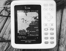
ICOM FP 561
The FP 561 was a pleasant, low-cost surprise. The tack sharp screen was reasonably visible in bright sunlight. This is ICOM’s first effort in the popular GPS/sounder arena, and we were impressed. We would like to see the map cartridge (PCMCIA card) moved from the bottom to the front for easier access. The FP 561 responded quickly to zooming and panning in the plotter mode.
The FP 561 employs a menu, so it was more difficult to use all the features without help from the manual. Some context-sensitive help is available on the screen, however.
Even though resolution is technically the same as several other units, it was clearly a step ahead in clarity. This makes the case for checking out units in person if at all possible, or buying with a no-penalty return policy. Numbers don’t always tell the whole story. Considering you get a sounder and GPS for $1,200 list, this unit should prove to be very popular.
Bottom Line: A brand new model with outstanding screen resolution. It’s so new you’ll have to ask about a discount catalog price.
Marinetek SeaMax
This plotter/sounder is unique among this group. It employs a cathode ray tube display (CRT), just like a small color TV. It consists of a basic plotter/sounder, with a separate cartography unit grafted on to the base of the CRT. The cartography unit enables the use of Navionics minicards. Our unit had the optional internal GPS (DGPS also is available). Addition of the cartography unit makes for an electronically seamless package.
We were able to view the display outside, but only with the use of the snap-on hood. The screen may also be set to black & white or amber. The screen resolution is a bit less than the other units of similar size, but the colors are richer and more saturated.
There are plenty of waypoints and routes, and up to eight separate tracks may be saved to memory. The unit is larger than all others due to the CRT and uses more power (36W) than all but the Datamarine, so this should be taken into consideration. The unit also accepts Loran input as well as GPS. A dedicated help key was appreciated for the many functions. There are several other dedicated keys, but the unit is primarily of the menu-driven persuasion.
Bottom Line: The CRT display is old technology. Price is $1,200 list; we are not aware of a discount mail-order source.
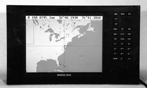
Simrad Shipmate CE40
The CE40 is just about perfect in design and execution. It has a very small (considering the screen size) die-cast aluminum and polycarbonate case and waterproof exterior combined with an elegant and sophisticated operating system for a most satisfying GPS navigator. Think of it as the Lexus of GPS units. It has every feature we consider important, including a full keyboard as well as the only 14-channel GPS we have seen. It does not have the unequivocal bright sunlight visibility of the Datamarine unit, but uses less than half the power. In bright sun, with an optional snap-on hood, the CE40 functions admirably.
It uses a “Windows” metaphor with six pull-down menus that display simultaneously across the top of the screen—a sort of super soft key setup. The six primary menu categories stay open while you scroll across the top, view the submenu selections, and directly access the desired numbered function with a keyboard key.
Some of our other favorite functions include the ability to display two different maps at different zoom levels at the same time. The ability to direct zoom to any level via the keyboard is also really slick. For added versatility the unit can display Loran or Decca chains as well. It has broad input and output capabilities for effective system integration, including a duplicate remote display.
The DGPS locks onto the strongest two stations automatically for added security in the DGPS mode, all from a small combined GPS/DGPS antenna with a single cable connection. This is the kind of integration we like to see.
The port information function is extensive, displaying lots of information without having to dig through menus. The sounder function, not tested, appeared to be as sophisticated as the GPS side with three frequencies and extensive options.
The extraordinary memory capacity is overwhelming. Operation is intuitive and can be as automatic or manual as the user chooses, with four pages and five sub-window combinations. We would, however, like even faster screen redraws; we were able to lock it up with incessant playing with the controls, necessitating a restart. That aside, we were most impressed with this plotter.
Bottom Line: Very highly recommended. Like the Datamarine, the Shipmate CE 40 is expensive at $6,500; we are not aware of a discount mail-order source.
Si-Tex Nautilus
The Nautilus has an outstanding feature set at an attractive price. Along with all the expected features, such as multiple map displays, are items normally expected on more expensive units. There is an abundance of event and mark points to annotate the map display with personal notations and symbols. A pan function allows you to center the map display three ways: on the cursor, on the GPS position or on a designated position. A variable range marker function allows you to place a range circle around the boat.
The particularly comprehensive port information function has a “nearest feature” capability that displays information such as the closest hospital. The unit requires an external GPS/DGPS or Loran signal, and features two C-Map NT card slots for either expanded map coverage or for employing a user-programmable C-Map cartridge as expanded memory storage for waypoints or route data. The user card is formatted by the unit’s software and data is stored just like a floppy disk, only in a rugged C-Map cartridge. Sunlight viewing was about on a par with the rest of the group, with direct, bright sunlight washing out the display.
Bottom Line: A Best Buy at $1,500 list, $989 discount from Consumer Marine Electronics (800/322-2628).
Conclusions
Going in, the big question we had was whether the color screens were visible in direct sunlight, and the short answer is a qualified yes. At about 75% of the viewing angles the screen is visible, but in direct sunlight the color washes out. The screens are much more visible than the active matrix computer screen that we used for comparison. The Datamarine was by far the best (visible at all angles), followed at a distance by the Garmin. (Datamarine ironically doesn’t recommend installation with constant exposure to direct sunlight.) The rest were quite close. If mounted outside in bright sunlight with no cover or shade, stick with grayscale. If there is a mix of lighting, then the case for color is much more compelling. Multiple tracks can be in different colors, as can many other variables, making navigation easier.
Color plotters use more power than similar grayscale models. In actual use, Garmin was the low-power champ at 13W.
We were a bit dismayed by the awkward location of the cartridge slots in the ICOM and Si-Tex units, because changing bottom-mount cartridges was a pain with the bracket mount and would be worse with flush mounting. With overhead mounting, however, it would be a snap to change cartridges.
We were also concerned with the ventilation holes showing exposed circuit boards in the Datamarine. This may be the price of such a powerful processor. Nevertheless, it has a huge, dazzling screen that’s a real showstopper under all lighting conditions. Two cartridge slots are a plus.
The Marinetek’s CRT display offers no compensating benefit, and one needs the detachable hood (included) for sunlight viewing.
Our overall mid-price favorite was a tie. The Furuno, based on the versatile screen choices, slick DGPS interface, and waterproof construction, is a great unit. If the price is too steep, check out the slightly smaller screen of the 1650D, as it has all the same features minus the remote control option. We also liked the Garmin, despite its slow zoom, which could be a bit frustrating as it takes several seconds for each screen change. It has a terrific feature set, a bright screen, and excellent customizability.
The ICOM and Si-Tex are both excellent plotters and well worth considering. For the more budget-minded owner, the Si-Tex has an outstanding feature set, and excellent usability. It is our choice for color plotters under $1,000 at discount prices.
Overall, the set we truly lust for is the Simrad, with its wonderful display, terrific features and rock sold exterior. Its $6,500 price tag is not for the faint of wallet. Skipper Marine Electronics carries the Simrad at discount prices (800-SKIPPER). You have to call for the current price.
We would not make a choice based on cartridge format, although the C-Map cartridge has more port information as well as graphical tide tables in some compatible units. Look for more port information as software is updated and map cartridges are revised. Map-wise, both Navionics and C-Map are very close.
Contacts- C-Map/ USA, 133 Falmouth Rd., Mashpee, MA 02649; 800/424-2627; www.c-map.com. Furuno USA, 4400 NW Pacific Rim Blvd., Camas, WA 98607; 360/834-9300; www.furuno.com. Garmin International, 1200 E. 151st St., Olathe, KS 66062; 913/397-8200; www.garmin.com. ICOM America, 2380-116th Ave. NE, Bellevue, WA 98004; 425/454-8155. Marinetek, 419 Renolds Circle, San Jose CA 95112; 408/437-8987. Navionics Inc., 6 Thacher Ln., Wareham, MA 02571; 508/291-6000; www.navionics.com. SEA/Datamarine, 7030 220th St. SW, Mountlake Terrace, WA 98043; 425/771-2182; www.sea-dmi.com. Simrad Inc., 19210 33rd. Ave. W., Lynnwood, WA 98036; 425/778-8821, www.simrad.com. Si-Tex, 11001 Roosevelt Blvd., Ste. 800, St. Petersburg, FL 33716; 727/576-5734; www.si-tex.com.


