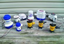
PDA/GPS/Charting Package
For quite a while now, we’ve been testing and reviewing a spectrum of devices that use electronics to help with your navigation. These have included GPSs, both handheld and fixed-mount, chart-plotters of varying size and capabilities, and software that enables a computer to interact with a GPS, thus enabling you to plan trips, set waypoints, and—if you carry a laptop on board with you—display exactly where you are on an electronic chart.
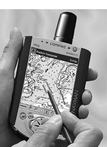
A recent wrinkle in electronic navigation allows you to use a handheld computer to work in harness with a GPS. Since the capabilities of a handheld aren’t up to those of a laptop or desktop computer, this next step isn’t as simple as it might appear.
Maptech makes a version of its Offshore Navigator program called the Pocket Navigator. It works with any handheld computer that runs on the Microsoft Pocket PC operating system. At press time, Maptech is on the verge of releasing a new Palm-based system, so check the Maptech website for further information. Obviously, the more advanced the PDA, the better the system should run. We did our tests of the Pocket PC-based Pocket Navigator on a Compaq 3650.
The Pocket Navigator can use any of MapTech’s extensive library of aeronautical charts, NOAA Marine charts, and USGS Topological maps.
What We Tested
The handheld computer and the appropriate software provide two of the three elements that are required for real-time navigation. You also need a GPS that can interface with the computer. Maptech markets a particularly neat GPS adapter for a handheld. It’s an import from Navman in New Zealand, and consists of a sleeve containing all the required electronics that slips over the handheld computer and connects electrically with a built-in plug, eliminating the need for any cables. The Navman sleeve has a built-in antenna, and provides no display of its own, making use of the handheld’s display (typically 2-1/4″ x 3″) The entire package—sleeve plus handheld—is easy to handle and, once you get used to using a stylus instead of a keyboard and mouse, easy to use.
The sleeve runs off the batteries in the handheld, limiting operating time to 2-3 hours. It comes with a 110v AC adapter, and a 12-volt cigarette-lighter attachment. Battery life shouldn’t be a problem if you can keep it attached to the boat’s 12-volt system. Otherwise you’ll need extra batteries handy.
The sleeve also comes with a clip-on flexible gooseneck stand that mounts with a suction cup. The suction cup worked reasonably well for us, but a more secure mounting wouldn’t be hard to improvise.
The handheld computer and its associated software will work with other cable-ready GPS units, of course, but at a considerable cost in convenience and ease of handling. Having two separate boxes connected with a cable can produce a shortage of hands when you’re trying to use the stylus to enter waypoint data.
How We Tested
Our usual practice is to test navigation equipment by navigating with it. We took the handheld/Navman/Pocket Navigator combination on board and put it through its paces in the waters of Western Long Island Sound. We checked out accuracy, though that’s seldom a problem with GPS equipment nowadays. We concentrated on “human” factors—convenience, viewability under varying light conditions, and clarity of display.
In addition, we took it ashore and checked it out in a car, and on foot—it’s also recommended for hikers.
What We Found
We weren’t too surprised to find that the system worked. What was a bit surprising was the clarity and brightness of the display. We’ve had unfortunate experiences with the displays of laptops fading away to illegibility in bright sunlight. Not the case here. The Compaq IPAQ handheld has a screen with a reflective backing that actually appears brighter in sunlight (we’re told that this type of screen is also used on other Pocket PCs.)
A handheld computer has a screen that’s large compared to that of most handheld GPS receivers; small compared to that of a laptop or a large fixed-mount chartplotter. Good brightness and very high resolution, though, make it more legible than many devices with larger screens. Typically, a handheld computer will have a pixel density of 240 x 320. That’s about two and a half times the number of pixels per inch found in a Magellan 6500 chart plotter, or a Garmin GPSMAP 215D. A comparison with the displays of handheld GPSs is simply no contest. The Pocket PC’s display is in color, rather than monochrome, and the resolution is 2-1/3 times that of, say, the Garmin eMap, one of the better displays among hand-held GPSs.
Regardless of clarity, though, it must be remembered that the screen of any electronic display is still very small when compared to the size of a paper chart. While you can zoom out to display a larger area on your screen, the further out you zoom, the less detail you can make out. The 2-1/4″ x 3″ screen of a handheld is fine for displaying chart details, but correspondingly less effective in showing wider areas.
The Pocket Navigator uses raster charts, which it displays in the familiar colors of paper charts. They’re available on CD—an arrangement that we prefer to systems that use cartridges—or via download from the Internet. Most people will use a home desktop or laptop to download the charts, and then install the desired charts on the handheld unit. The handheld computer can store 5-10 charts or topo maps at a time, though you can purchase additional storage in the form of flash cards if you need more. The Pocket Navigator doesn’t support quilting, so if your course takes you past the boundaries of a chart, you have to activate the next chart.
Handheld computers, unlike their bigger siblings, don’t have mice or keyboards. While some of them have a few buttons—the Compaq IPAQ we used has a four-way scroll button—most of your interaction with the computer will be with a stylus. Tapping the screen with a stylus is the equivalent of clicking with a mouse: a quick tap does much the same thing as a left-button mouse click, a tap-and-hold works like a right-button click, and a hold-and- drag is equivalent to a click-and-drag with a mouse. There are virtual zoom-in and zoom-out buttons on the screen, as well as scale-in and scale-out options to change charts.
A tap on any point on the displayed chart will produce a small box that shows latitude and longitude (although we wish there was a large single button to click on to provide a full-screen display of the traditional GPS outputs: Latitude, Longitude, Speed, and Course.) Other functions can be performed by tapping on a series of drop-down menus. Setting a waypoint, for instance, involves tapping Menu, then Overlay, then Create Route and then the chart location you wish to mark. You then tap-and-hold the mark you’ve created to open a Properties menu that allows you to name the waypoint and select the symbol to be displayed and to add any comments that seem appropriate. This all sounds more complex than it actually is, but it’s still an operation that works best when the boat isn’t bouncing around.
Pocket Navigator doesn’t have the bells and whistles of the more elaborate programs such as Nobletec’s Visual Suite or the CAPN. It does a fine job of handling navigation and chart-plotting functions, though, and provides quite a few features unavailable on dedicated chart-plotters.
The Navman GPS sleeve worked well, though we’d like to see some provision for an external antenna—we tended to lose signal belowdecks. It’s not WAAS compatible, but the slight loss in absolute accuracy shouldn’t pose much of a problem considering the small size of the displayed chart.
The sleeve appears to be very well made, and presented no problems in use. If you already have a handheld GPS with cable connections, you could bypass the Navman sleeve, but you’d lose the convenience of a very neat single package.
Conclusions/Recommendations
Let’s say right off, before we get down to quibbling, that we like the Handheld/Pocket Navigator/Navman combination quite a lot. Its excellent display alone gives it a clear advantage over most chart plotters. The raster charts that Pocket Navigator uses are much clearer than the somewhat primitive vector charts used by most chartplotters and handheld GPSs with charting capability.
We also like the idea of using a multi-purpose computer in conjunction with a GPS, rather than a single dedicated instrument that functions only as a chartplotter. If nothing else, the computer program has the capability of upgrading the program as new software is developed. Navigation software for handhelds is just becoming available, and we think it’s safe to assume that improved programs will be available in the not-so-distant future. And the handheld is always available for other activities, such as handling e-mail or playing solitaire.
If you don’t have or need a Pocket PC-based PDA for other activities, this approach will be expensive: such a handheld computer costs (this week) anywhere between $250 and $700, depending upon model and available discounts. If you already have a PDA or intend to buy one for its other uses, the cost picture is much more attractive. The Navman sleeve/Pocket Navigator package sells for $349; if you have a compatible handheld GPS you can purchase a connecting cable for $20, and the Pocket Navigator software for $100.
A neat feature of any handheld navigation system is that you can take it with you in your car, or on a hike. The handheld computer combination we tested worked very nicely on the highway and afoot; the charts are a vast improvement over what we’ve seen in dedicated chart plotters. We did miss the lack of an external antenna on the sleeve, though, when we entered weak signal areas.
Contacts
Compaq (HP) 800/752-0900 www.compaq.com.
Maptech 888/839-5551 www.maptech.com.
Navman, 866/628-6261 www.navman.com.
———-
ACR ThermaBlanket
Here’s an oldie but goodie. Thumbing through a marine catalogue, we noticed an item from ACR called a ThermaBlanket. It’s not a product that’s new to us (or to most anyone, for that matter) but it’s one that we hadn’t considered for a while—really an essential component of the well-considered emergency/first-aid kit since the ’60s, and something we shouldn’t go without if we think we might have to sit out a rescue for even a few hours in cool or cold climates.
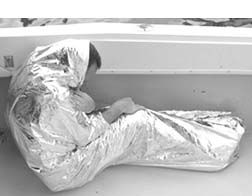
ThermaBlanket is a sheet of thin aluminized Mylar. It unfolds from a small packet, 3-3/4″ x 5″ x 3/4″, to a full 54″ x 84″ blanket. If you wrap it around yourself, body heat loss is reduced by 80 to 90 percent. Originally a spin-off from the space program—products of this nature are generally referred to as “space blankets”—these inexpensive sheets can be life-savers in terms of preventing hypothermia. The reflective surface minimizes heat loss through radiation, which can account for a major portion of the body’s total heat loss. The Mylar film isn’t porous, so heat losses due to convection are similarly reduced. And while the space blanket isn’t, in itself, a good insulator in the sense that foam or glass wool is, it has some effect in reducing conductive heat losses.
It can be used as a reflector, a rain-collector, and in probably half a dozen other ways if pressed into service. You get all this for about five bucks.
Contact – ACR, 954/981-3333 www.acrelectronics.com.
———-
Tool Leash
We’ve met a few people who have never dropped a tool overboard. These are people who have never worked on their boats. The solution to the problem has always seemed simple enough—just attach a lanyard to the tool. Trouble is, it just doesn’t work too well. There’s the problem of attaching the tool to the lanyard, and the problem of the lanyard interfering with the use of the tool, and the problem of dealing with several tools.

So we were glad to encounter the Tool Leash from Fastening Solutions, a clever and simple solution to all those problems. It consists of three parts. First are nylon “tool ties”—basically familiar cable ties. You wrap the tie around the tool, slip the end of the tie through the loop at the other end and pull it tight. Trim off the excess tail, and (for security’s sake) apply a drop of instant glue to finish the job. Each tool tie has a small molded-in eye. The Tool Leash comes with 10 tool ties, and you can purchase extras.
Part two of the Tool Leash is a “coil leash.” This is a 5-inch long coil with a swivel snap hook at one end and a wire ring at the other. You snap the hook onto the eye in the leash, and attach the ring at the other end to part three—an aluminum carabiner that can be used to anchor the Tool Leash to a belt loop, railing, rigging, or whatever. The coil leash is stretchy—it can extend from five inches to almost four feet—so that there’s a minimum of interference with the use of the tool. It’s strong, too. The manufacturer tells us that coil leashes have been tested to 30 pounds. Being of a suspicious nature, we took an 18-volt cordless electric drill, attached a tool tie to its handle, attached a coil leash, and dropped it. No problem. The coil leash not only withstood repeated drops, but returned to its original 5-inch length when we retrieved the drill.
The Tool Leash comes with two coil leashes. The carabiner will accommodate up to four at a time, but to accomplish this you’d have to buy two Tool Leash kits. The snap hook makes switching tools…OK, a snap.
The Tool Leash is a good system—compact, effective, versatile, and it fills a real need. At $9.99 for the kit, it soundly beats trying to make one from scratch.
Contact – Fastening Solutions, 800/232-7836 www.fasteningsolutions.com.


