Photo by Jonathan Neeves
We have been following the developments of Navicos Broadband radar since its debut in 2009. We sea-trialed the BR24 last year (PS, July 2011). Just as we were setting up a 3G unit for field testing on a 38-foot sailing catamaran late last year, Navico announced the release of its new 4G series, which promised greater range, better target resolution at close range, and other changes. A head-to-head test comparing the two was impossible to pass up.
To simplify the installation and reduce costs, we decided against a side-by-side comparison with two different multifunction displays (MFDs). Instead we evaluated targets on one unit, swapped to the second unit, and then evaluated the targets again.
We used a Simrad NSS7 multi-function display (PS, November 2012). Broadband has gained considerable acceptance, particularly among sailboat owners attracted to its relatively low power requirements. Four of the six boats in the most recent Volvo Around the World race used the 4G radar.
Installation
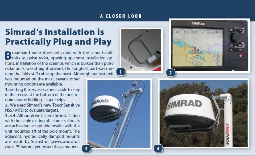
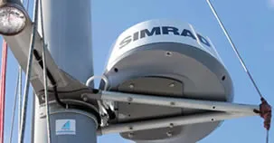
Unlike most broadband tests, which mount the test unit at deck level, PS mounted the scanner on the mast, 20-feet above the waterline. The location height offers results more relevant to typical boat installations, and because radar is line-of-sight transmission, it also gives better long distance target identification.
Installing the broadband units is very simple; the most tedious part is making the cable runs, a time-consuming process that requires two people. In terms of flexibility, radar cables are about as cooperative as fishing rods.
These broadband scanners are a bit bigger and taller than their pulse-radar, 2-kilowatt competitors. We found that it was best to simply hoist the test units, using a ring-bolt on the base of the unit, to a person positioned aloft, where the scanner was to be mounted.
Conveniently, the scanners bolt-holes are identical to those used for the equivalent pulse-radar scanning units from Garmin and Raymarine. The dome and base plate are held together with small nuts and bolts, and these are not to be touched. In fact, there is a small piece of adhesive tape at the joint with a printed message saying that if the tape is broken, the warranty is invalid. It would be an easy thing to do by accident.
Simrad is a Navico brand, and broadband radar is also sold under the names Lowrance and B&G. The Lowrance unit comes with a 33-foot mast cable; the others are 65 feet; and all have a 98-foot cable option. The 6-foot-long ethernet cable that connects the radar interface box to the MFD is standard, but the interface box is sold separately.
If you require a MARPA (mini-automatic radar plotting aid) and chart overlay, you will need to add a fluxgate compass. A mast-mounted unit will require the 65-foot cable. You need about two feet of extra cable coming out of the mast to work comfortably while installing, and a surprising length to pass through existing conduits to the interface box, which needs to be located in a dry location. Using standard cables, the interface box needs to be within six feet of the MFD; longer cables are optional.

How We Tested
Navico representatives pointed out that to best compare the two units, we should use them in the same geographic location with the same settings and same MFD. They also advised us to compare scanner performance simultaneously. This was impossible. We had only one scanner platform, one cable, one interface box, etc. By varying the days of testing, Navico suggested, environmental factors could skew our results.
To offset potential environmental variables, we ran a number of tests with each scanner on alternating days. We were able to test both units on the same day once. There was about a four-hour time gap between tests on that day.
The scanners were conventionally orientated with the scanner facing forward of the mast, and the cable connector exiting aft. The scanner will work if it is oriented 180 degrees, but the cable connection-although it is well sealed against the elements-is less exposed if it faces aft.
The nice thing about broadband scanners is that the energy emission level is so low they can be located at deck level. Raising the scanner will provide increased range, but it will also increase the minimum range within which targets cannot be detected. Theoretically, a conventional, 20-foot-high scanner should detect targets no closer than about 60 feet. Practically, the 3G radar detected targets within 16 feet of our test boat-remarkable, but rarely necessary in practice.
We have seen broadband units mounted behind dedicated 6-foot pylons with gimbals, and although locating the scanner directly behind a pylon seems illogical, the obstruction does not appear to interfere with the image. We saw no evidence of interference aboard a demonstrator boat that had this type of installation, and we later confirmed this by placing a two-inch diameter stainless-steel tube vertically in front the scanners on our test boat. The stainless tube had no impact on the radar image.
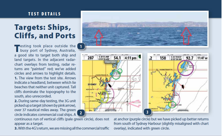
Our test location off Broken Bay, just north of Sydney, Australia, was at the southern end of an ocean anchorage for large commercial vessels, about 600 feet long, waiting to load coal at the port of Newcastle. The vessels anchor a few miles offshore in a long line stretching from about 13 to 50 miles north. Within the 37-mile range of the test location were 11 large vessels; neither test unit could mark all of these.
We worked 7 nautical miles offshore to ensure the radar had a good view of the ships. Conditions during testing brought seas of 1 to 4 feet with a lazy 4- to 5-foot swell, with visibility ranging to 25 nautical miles. The atmosphere was clear, typical sunny winters day on all days of testing- no rain no fog.
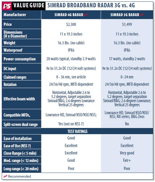
We found that the 3G unit could reliably identify these targets (ships) up to 20 nautical miles, and with the 4G, up to 24 nautical miles. Targets beyond 30 nautical miles winked on and off on both units. All of these ships were large, typically 600-feet long, and being empty, they were sitting fairly high out of the water. Other targets included the Norah Head lighthouse, located about 22 nautical miles north, a 90-foot concrete tower with its base on a rocky promontory 60-foot above sea-level.
Our test boat did not have AIS installed, but we were able to check vessel positions through a vessel monitoring website during the test so that we could identify any definable targets.
What We Tested
Both of the units we tested were offspring of the original BR24, developed in New Zealand. When PS first saw the BR24, the original Broadband unit, we were impressed with its short-range target detection and its low power usage (compared with pulse radar). We were a bit skeptical of the claimed range of 24 nautical miles, but when the 3G unit was announced, it also had a 24-nautical-mile range, and power usage had crept up from 17 watts to 18 watts and from 1.8 watts to 2 watts on standby. This compares with approximately 28 watts and 9 watts for a 2-kilowatt pulse-radar scanner. Our tests of the 3G show that it can sometimes can detect targets at 24 nautical miles, and in some cases further, but the 24-mile claim is an optimistic assessment and not easy to duplicate. We were curious to see how the 4G, with an even greater claimed range, would perform.
The 4G unit has an advertised range of 36 nautical miles, plus beam sharpening for sharper images, and the option of simultaneously monitoring targets at two different ranges. Like the 3G, it offers faster scanning at close range, which means there are quicker updates for nearby targets. Power for the 4G has crept up further to 20 watts and 2.9 watts standby, still parsimonious compared with normal pulse radar. All the broadband units switch on almost instantaneously, compared to the 70- to 90-second delay for the warm up of a pulse radar.
The 3G and 4G units have identical microwave transmitters and receivers. Technically, they have the same range, and in a perfect world, both will have identical target responses. The difference between the two units is that the 4G transmits 2.7 times as often as the 3G, increasing the chance of the receiver identifying a response. The other difference between the 3G and 4G is a more sensitive processing gain for the 4G between the 1- to 36-nautical mile ranges.
3G Findings
Prior to installing the 4G radar, we were able to ocean test the 3G on short cruises and were impressed with the performance. In our view, it met the needs of a leisure sailor-even if the claimed long-range performance was hyperbole, in our view.
We detected targets at 29 nautical miles (a power station chimney), 27 nautical miles (commercial vessels or rocky promontory), and in very flat seas, a ship beyond 37 nautical miles (a large commercial vessel). However, these results were the exception. For example, we could not repeat the 27- or 37-nautical mile responses.
On the downside, the 3G radar would not detect low shorelines, even at 10 nautical miles. However, the unit clearly targets large commercial vessels, 575 feet long, within 20 nautical miles. Beyond 20 nautical miles, ship targets blink irregularly-as we had seen in the BR24. The 3G unit will detect buildings at around the claimed 24-nautical mile range, but will not consistently pick up even large 100-foot vertical shoreline rock faces until within the 12- to 16-nautical mile range.
Performance of the BR24 3G and 4G at short range is stunning. Although we never need to see our own bowsprit with radar, it is reassuring to know that detection can be that close, particularly as pulse radar has a dead zone of about 150 feet, within which nothing is detected. Arguably, you should visually see targets at 150 feet, but try to tell that to the weary mariner at 2 a.m. with a light rain falling and a black-hulled yacht ahead with no anchor light.
4G vs. 3G Findings
Our first trials with the 4G were a disappointment: Range was less than we had found with the 3G. Even after we carried out a software update, we saw no positive effect. Navico representatives sent one of their senior engineers to monitor our tests, with another new 4G scanner. The tests were as inconclusive as we had already found. We were provided with new software, again to no positive effect.
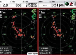
Finally, we tested the original 3G against the new 4G in the same location (within 200 meters by GPS) but with the test times two to four hours apart. We took screenshots for both units at about 1 nautical mile and 7 nautical miles offshore. These final screenshots were made in calm seas. On this day, we saw very little difference in performance at a long distance. Both units picked up the first five or six of the 11 distant ships lining up for entry into Newcastle. Neither picked up the Norah Head lighthouse.
All in all, the 4G was better at long-range, but it would be difficult to quantify the improvement-certainly not 50 percent, as Simrad advertises. Both units, 3G and 4G, identified large buildings in downtown Sydney at 20 nautical miles. The 3G unit specifically highlighted a coal-fired power station at 29 nautical miles.
Natural landforms were more problematic. The 3G unit is reliable to 12 to 16 nautical miles (and occasionally 20 nautical miles) with large monolithic coastlines. Low sandy coastlines, sloping gently to 60 feet above sea level, remained undetected until within 10 nautical miles.
The 4G unit performed better from 14 to 18 nautical miles-offering reliable detection of definitive coastlines-and occasionally 22 nautical miles. Again detection of flat coastlines was disappointing, with 12 nautical miles being a realistic expectation. Both units would detect man-made structures, ships and buildings, at 20 nautical miles, but could not detect 100-foot cliffs at the same range.
Long Range
To cut to the chase in the matter of long-distance targeting in broadband radar: The 3G radar will target large commercial vessels fairly reliably up to 20 nautical miles and will identify targets beyond, but these will only appear on the screen temporarily, and they would be easy to miss. The 4G radar extends that effective range to about 24 nautical miles, but beyond that, again, the targets flash on and off.
Both units can target big commercial vessels at considerable distances, almost 40 nautical miles, but this is not reliable. The 3G will define prominent coastal features at ranges up to 16 nautical miles, with the 4G picking up the same coast at about 20 nautical miles. However, low, gently sloping coastlines are not targeted until within 10 nautical miles (3G) and 12 nautical miles (4G).
In response to our findings, Navico presented evidence that the units do in practice meet their claimed range. An image they provided clearly showed that the 4G can detect land at 32 nautical miles, and the 3G at 23 miles, but in both cases, the targets were summits of 2,000-foot mountains.
In effect, our own results were similar to those produced by Navico. We just have different views on how this performance should be represented in advertising. In our view, an ability to pick up the top of a high mountain at 32 nautical miles (or 23 nautical miles), but not define the closer coastline, is not a feature upon which we would want to hang our hats.
Short-range Targets
Other than the claims for longer range, the other major feature for the 4G was beam sharpening, or beam focusing. This allows differentiation of targets close together, particularly those close to the scanner. It works well beyond expectation. Within less than a mile, the 4G radar showed that big targets on our 3G radar, were in fact two or more individual boats in the mooring field.
At distances closer than 100 yards, performance is about the same, but beyond that, there is no comparison: The 4G systems meets all claims for its performance. The NSS7 makes beam sharpening automatic, other Simrad MFDs offer this as a user-controlled feature.
Another of the 4Gs features is its ability to show a split-screen image, with one screen at one range and the other at longer range. This gives you an ability to see targets close at hand (within 300 yards), while simultaneously monitoring activity at 4 nautical miles. PS was unable to test this function as it is not available on the NSS7 display. However, we were able to use this on another boat, and it worked as advertised.
Conclusion
In our view, both the 3G and 4G, with the scanner mounted at 20 feet above sea level, offer adequate protection against ship collision. Likewise, the detection range, even of a low coastline, is adequate for most navigational situations that a skipper might encounter. However, we do regard the advertised range of these units to be optimistic.
Based on our test results, you are as likely to target a commercial vessel at 30 nautical miles with the 3G radar as you are with the 4G. It might flash up more frequently or clearly with the 4G, but it will still be there on the 3G. There may be slight improvements in the detection of land features, but wed gauge it at only 10 to 20 percent.
Along with improved reliability at the longer range, the other technical innovation PS would like to see would be a sweep-and-sleep function. This would allow the unit to be left on and sweep at a user-set interval, say every 10 minutes, switching on full-time when a target is detected. If the target came within a preset guard zone, an alarm could sound and the unit switched to permanent display. Such a feature would also allow the unit to identify a blinking target at very long range when the watchstander might not see it.
In our view, broadband should not be looked at as a competitor to pulse radar but a new way to meet the needs of the modern sailor. In terms of long-range target identification, broadband simply does not yet compete with pulse radar.
If you need clarity and certainty at 24 nautical miles and further, buy pulse radar. If you can accept target identification at 12 to 15 nautical miles, desire low power usage, prefer instant on, and see advantages in short-range definition, then the choice, without any shadow of a doubt, would be broadband.
