GPS receivers, especially handheld models, is one of the few categories of marine electronics that lately has been undergoing significant changes. In contrast, VHF radio models seem to rarely change, and depth sounders havent done so in years.
Despite many new models, however, the GPS marketplace has matured considerably. There is virtually no difference in actual performance between models. Receiver sensitivity is no longer an issue and all models seem to sport 12-channel parallel receivers. More and more the difference between models is functional rather than technical.
A word about patch and quadrafilar antennas; the former are somewhat less position sensitive but have less gain to bring in signals whereas quadrafilar antennas have more gain but ideally should be adjustable.
For this round of tests, however, we did measure the operational parameters of each model. Position accuracy was compared to a known benchmark. Speed measuring accuracy was measured with a calibrated police speed radar, and bearing accuracy was checked against a known course. Each of these items was checked several times and the average errors entered in our results. Times to first fix and the average number of satellites tracked also were noted. When at all possible, tests were run on all units simultaneously in order to minimize variances attributable to differences in the available satellite constellation.
We obtained as many handheld models as possible from both Garmin and Magellan. The third maker of a handheld GPS, Lowrance, recently decided to repackage its GlobalMap 100 and reduce its price-under $200 at discount. It is the same as the model we examined in the June 1, 1998 issue, when we liked its ability to download maps and other information from a CD-ROM. Then the CD-ROM was standard; now it is optional. Unfortunately, Lowrance couldnt supply us with a unit for this test.
Garmin also could not provide us with its similarly priced new eMap handheld.
We also rated each model based on ergonomics, the visibility of its display and its appropriateness for marine use. With the proliferation of GPS receivers for land-based navigation, many otherwise good models simply arent designed for marine applications. The chart on page 18 summarizes information on each model and our test results. A more detailed description of each follows.
Garmin eTrex
The Garmin eTrex is the companys latest handheld model. Weighing just 6 oz. it is the smallest model currently available. The eTrex is very ergonomically designed, and according to Garmin, is designed to be held in the left hand. The eTrex is operated by five push-buttons located on either side of the unit. Power and page selection are on the right with up/down keys and an enter key on its left side. The top is reserved for the display and patch antenna.
With the eTrex, Garmin has introduced a RISC microprocessor to enhance its graphics and display capabilities. This also makes the eTrex very easy to operate.
On the downside, the eTrex is not a full-function GPS receiver. It can display five pages of information. A satellite status page shows its status and estimated position error (EPE). A pointer page displays the currently selected waypoints name, distance and estimated time of arrival as well as your current speed. The eTrexs next screen is a compass rose display. A map page is the eTrexs track plotter mode and also displays a north arrow. A menu page allows for setup and the storage of track routes and waypoints. A mark waypoint page is used to store new waypoints. This page is the only location that the eTrex automatically displays lat/lon. Location can also be displayed on the pointer page but this is not done so by default. No altitude display is available.
The eTrex performed well during testing; location, speed accuracy and bearing accuracy were within acceptable limits. However, in map mode the response of the north arrow appeared somewhat slow.
Bottom line: The Garmin eTrexs yellow and black color scheme and optional bicycle mounting kit is obviously designed for the general consumer market. For more than casual marine use it lacks functionality. It is, however, a great entry level receiver.
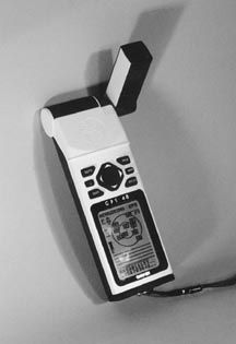
Garmin GPS 48
The Garmin GPS 48 is a full-feature, top-of-the-line handheld GPS receiver. It is small, lightweight and ergonomically well-designed. When held in either hand its six push-buttons and single large rocker switch are easily operable without obscuring its display. The helical antenna on its side is removable and also pivots for optimizing reception.
After a brief initial information display the GPS 48 goes into its satellite status display, which shows the available satellite constellation, signal strength bars for each received satellite, EPE, and battery level.
A position page can display speed, bearing, altitude, trip distance, position and time, and includes a tape-style compass display across its top. A map page shows bearing, speed and track plot. In addition, the GPS 48 has a detailed internal library of many navaids that are displayed here if they are within range of the display. A brief description of each navaid is given when in their vicinity or by panning the map to their location. While not truly cartographic in nature, this feature of the GPS 48 is very useful. For example, the displayed navaids can easily be correlated to those on a paper chart and then instantly used as a waypoint. The database stored in the GPS 48 is also updatable when changes to navaids occur. A compass page is Garmins default navigation page and shows bearing and distance to the selected waypoint as well as speed, bearing and estimated time en route. A menu page is used to customize functions and to reach 22 secondary pages. These secondary pages are used in the definition of waypoints and the set-up of many changeable parameters such as map datum, speed and distance units and display settings.
A man-overboard function, arrival and anchor drag alarms are also included. During testing, the Garmin GPS 48 performed very well. Position, speed and bearing accuracy were very good. It also tested at the top for the number of satellites received.
Bottom line: The Garmin GPS 48 is our top pick among non-cartographic handheld GPS receivers. It is designed for the marine market and is well made. Highly recommended.
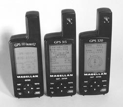
Magellan GPS 315/GPS 320
The full-function GPS 315 and GPS 320 are nearly identical. In fact, they even share the same manual. The GPS 320, however, is supplied with a carrying case and batteries while the GPS 315 is not.
The difference between these two is found in the waypoint database loaded into each. The GPS 315 includes a worldwide database of most cities, including those with less than 20,000 population while the GPS 320 database includes only major cities but adds regional buoys, lighthouses and fixed navaids. Magellan defines a region as either North/Central/South America, Europe/Africa or Australia/Asia. This arrangement seems to gear the GPS 315 for the land navigation market and the GPS 320 for the marine market.
The GPS 320 is priced about $50 higher than the 315.
The Magellan 300 series receivers are controlled by six push-buttons, one two-way rocker switch and a four-way rocker switch. Their displays take up the top two-thirds of the units front face with the controls located below it. This arrangement makes one-handed operation a bit awkward as the receiver must be held only by its lower third in order to reach its buttons with your thumb.
Nine screens allow access to all functions using the nav key. Magellans status screen shows relative satellite positions, received signal strength and a battery capacity bar display. The position screen shows lat/lon, elevation, estimated position error, speed, distance traveled, course and a compass tape display. The Nav 1 screen gives distances, SOG, XTE, VMG, COG and bearing as well as a compass tape display. A compass screen displays a compass rose and a COG arrow as well as bearing and distance to waypoint, COG and SOG. The Nav 2 screen shows only bearing and distance to waypoint, COG and SOG. A plot screen displays a track plot, bearing and distance to waypoint, active route and waypoint icons for both the user-entered waypoints and factory-defined waypoints. A road screen shows your desired course as a road with you at the arrow. Bearing and distance to waypoint, COG and SOG are also shown.
Magellan also includes a speed screen with a graphical speedometer, COG, SOG, bearing and both a resettable accumulated odometer and trip odometer. Finally, a time screen displays the current time, estimated time en route (ETE), time of arrival and the elapsed time.
Neither the GPS 315 nor the GPS 320 have provisions for the connection of an external antenna. An optional data/power cable is available to connect to a computer or differential receiver. Also available is Magellans DataSend software that contains storable points of interest and includes such vital locations as ATM machines which can be downloaded from a PC into each of these models.
During testing, the GPS 315 and GPS 320 performed adequately. Position, speed and bearing accuracy were good. However, when placed horizontally both of these models received fewer satellites than expected. Their quadrifilar antennas work best when vertical-not the most comfortable operating position.
Magellan DataSend software does allow for a wide choice of waypoints to be downloaded. However, its operation is not intuitive. Furthermore, the software shows only waypoints and city names. No roads, not even major highways, are included. This is confusing given the inclusion of such waypoints as highway exit ramps.
Bottom Line: The Magellan GPS 315 and GPS 320 performed adequately. However, sensitivity of their antenna position, poor ergonomics and the inability to use an external antenna, in our opinion, make them not the most suitable models for marine use.
Magellan GPS Blazer 12
The Magellan Blazer 12 is visually identical to the GPS 315 and 320, but on closer inspection we found this entry level model to be considerably different. It is lighter and does not have a data interface capability. Also, the two-way rocker switch found in the 300 series models is replaced by a single Enter button. Neither batteries nor a carrying case are included.
The biggest difference with the Blazer, however, is evident as soon as you turn it on. Its display is crude with segmented numbers and very minimal graphics. Only two screens are available. A position screen shows lat/lon and a simplistic satellite display. Received signal strengths are not shown. A navigation screen displays speed, bearing, and distance and bearing to waypoint. No track plot display is available nor an indication of EPE. During testing the Blazer 12 performed adequately.
Bottom line: The entry level Magellan Blazer 12 lacks functionality and features. Like other similar Magellan GPS, its fixed antenna is position-sensitive. Not recommended for marine use.
Garmin GPS 12, GPS 12XL, GPS 12CX
These three receivers comprise another family of closely related products. The GPS 12 and 12XL are identical in appearance. Each is controlled by six push-buttons and a four-way rocker switch. These controls are located just below a slightly angled patch antenna and above the display. This arrangement makes these models very easy to operate with one hand.
The GPS 12CX, with its color display, is similarly controlled with the addition of two additional push-buttons used to zoom the map page. This slightly simplifies the operation compared to the 12XL. There are no functional differences between the GPS 12CX and GPS 12XL other than the CXs color display.
Both have an external antenna connector and a separate connector for 12-volt power and data interface. The GPS 12, however, does not have provision for an external antenna and if connected to external power it must be fed 5 to 8 volts DC.
The 12XL and 12CX are preloaded with a database of cities. The basic GPS 12 does not include this data.
The main operating pages of all three models are identical to those of the Garmin GPS 48. Some submenu pages, however, are specific to each model. For example, the 12XL and 12CX include a find city submenu that is used in conjunction with their internal city database.
During testing, all three performed very well. Position, speed and bearing accuracy were all within acceptable limits. Our major criticism lies with the 12CX. Its color display adds considerably to its cost and provides little benefit. In fact, some colors appeared washed out in bright sunlight, making them hard to see.

Bottom Line: The Garmin 12XL is our pick for best value within this family. The plain vanilla GPS12 is recommended if cost is a factor and you don’t need an external antenna. The 12CX, on the other hand, does not provide adequate advantages to justify the cost of its color display.
Cartographic Models
The Garmin GPS III Plus is an interesting, if not unique, product. Its triangular shape can be easily held in ones hand or placed on a flat surface, ostensibly a car dashboard. Its quadrifilar antenna is adjustable and removable and its display orientation can be changed with a single keystroke to either vertical or horizontal. Truly remarkable is that the GPS IIIs internal database includes a street map containing most major and secondary roads for the entire US as well as a listing of available services at most highway exits.
The GPS III Plus is controlled by eight push-buttons and a four-way rocker switch.
There are six main pages to display information. A satellite status page is similar to Garmins other models. A position page shows a compass ribbon, speed, trip timer, average speed, trip odometer, sunrise and sunset times as well as position and current date and time. The map page shows lat/lon, a zoomable street map as well as speed, time and distance to next waypoint, and a course to steer pointer. Its compass page displays a compass rose along with speed, current time, and time and distance to the next waypoint. A highway page shows a compass ribbon, pointer, speed and time and distance to next waypoint. Finally, an active route page gives information on the route currently being followed. Page-specific menus can be accessed as needed.
The Garmin GPS III Plus tested very well. Position, speed and bearing accuracies were all within acceptable limits. As expected, received signal strengths were better with the antenna oriented vertically. However, this model is obviously not intended for marine use. It does not contain any navaid or other marine data. In fact, when we positioned the cursor over the Patapsco River, near Baltimore, it simply displayed Chesapeake Bay. The GPS III can display and manipulate considerable amounts of data, but, its display is much too small to make effective use of it. Trying to view it while driving would be very difficult, if not impossible.
Garmins Map Source software can be used to download residential road details as well as point-of-interest information. Some coastal navaid information is also available on the Map Source Roads and Recreation CD-ROM. A World Map CD-ROM contains a worldwide database of major highways, railroads, navaids and other information.
Bottom Line: The Garmin GPS III Plus is a very functional, interesting and well-made product but not one intended for marine use.
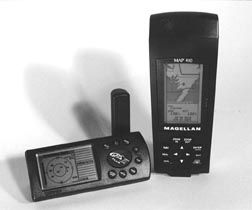
Magellan Map 410
The Map 410 is Magellans entry into the subcompact chartplotter market, designed to compete with the Garmin GPS III Plus. The Map 410 is about 1-1/2 times larger than Magellans 300-series models. Like them, its display is mounted above its controls, thus making one-handed operation slightly awkward.
The Magellan Map 410 is controlled by six push-buttons, a two-way rocker switch and a four-way rocker switch. Its quadrifilar antenna is adjustable and removable.
The Map 410 has nine screens: A time screen, status screen, Nav 1 and Nav 2 screens, position screen, compass screen, road screen, speed screen and map screen. These are largely identical to those found in the Magellan 300 series. A course deviation indication is added to the bottom of the compass screen and the map screen replaces the 315 and 320s plot screen. A temperature display that can be calibrated is also added to the status screen. One can choose the Map 410s primary usage-land or marine. This setting affects the units used, such as knots vs. miles per hour as well as the look of the map display. Unfortunately, the unit must be reinitialized to change this setting.
Magellans map display is not as crisp as Garmins. Lines representing major highways seem too wide. The map was almost unusable when looking at a major city. Navaids are included in the database but seem to be given secondary status. On each map redraw they appear about five seconds later than land details. This would make navigating at any speed difficult. When displayed, navaid names overwrite each other, especially when they are closely spaced. This results in an unreadable display of horizontal gray lines.
During testing, the Map 410 performed well. Position, speed and bearing accuracy were all acceptable. However, cursor response to movement was sometimes slow. Periodically, it would not move for several seconds after depressing the control. This possibly indicates insufficient microprocessor performance.
Bottom Line: Not recommended as a serious navigation tool. We judged the length of time required to display navaids unacceptable. Further, the overwriting of information is an apparent software flaw.
Garmin GPS Map 175
The GPS Map 175 is a true portable chartplotter. It is considerably larger than Garmins other handheld models, but also sports a considerably larger and therefore more visible display. Unfortunately, its size makes one-handed operation more difficult than smaller models. Nevertheless, it is ergonomically well-designed.
A patch antenna is mounted at a slight angle at the top of the unit. This is followed from top to bottom by control keys and its display. A multi-pin data/power connector, antenna connector and cartridge slot for Garmin G-Chart cartography are located on the bottom and side of the unit. Control is via eight push-buttons, one two-way rocker and a four-way rocker switch.
A general base map showing major roadways is included. However, if more detail is desired a cartridge must be inserted for a given area. Without a cartridge this model will not zoom in below its 16-mile scale. We are disappointed at this limitation and that no navaid information is contained in permanent memory. However, the amount of increased detail available with a cartridge map is worth the inconvenience of dealing with them. Realistically, most boat owners will never need more than one or two cartridges.
The GPS Map 175 uses four primary screen pages to display information. A status page gives satellite and battery level information. A position page shows position, time SOG, COG, altitude and trip distance as well as a compass ribbon. A map page can display a full screen map or a two-thirds size map with navigational information above it. Finally, a navigation page has a road display, pointer and shows ETE, VMG, COG, bearing and distance to waypoint as well as a compass ribbon. Various menu pages can also be accessed to control user settings.
The GPS Map 175 tested very well. It was easy to use and performed as expected. All measured parameters were within acceptable limits. Especially notable is that chart detail automatically changes based on zoom level. This prevents the excess clutter and overwriting that was found with the Magellan Map 410. Also, Garmins chart cartridges can be changed on the fly without turning the unit off. Our only criticism is that additional map information is not downloadable into this model from a computer. It would be nice if cartridge updates could also be accomplished in this fashion. For example, an update could be purchased from Garmin via the Internet and then stored into the appropriate cartridge. The ability to make up custom cartridges from computer cartography would also be desirable.
Bottom Line: The Garmin GPS Map 175 is a true portable chartplotter. Highly recommended.
Magellan NAV 6000
The NAV 600 is Magellans full-size portable chart plotter. Like the Garmin GPS Map 175, it is considerably larger than Magellans other models but also has a much larger and more readable display. The Nav 6000 has a fixed patch antenna mounted at an angle on top. Below its antenna is the display, followed by a row of four soft keys whose functions change depending on the screen being viewed. Below these are eight regular push-buttons and a four way rocker switch. Connections are available for an external antenna and a data/power cable.
The NAV 6000 has five primary screens. The map screen can show either a full-size map or a smaller map with navigational information below it. The Nav 1 screen displays bearing, distance, COG, SOG, degrees to turn and VMG in two larger windows. Below these in a smaller font are shown location, elevation, time and date. The Nav 2 screen shows course to steer, distance, VMG and ETA in large type. Each of these lines can be customized to show other data instead. A pointer screen shows a compass rose, COG, SOG, bearing and distance.
The NAV 6000 uses C-MAP NT cartridges for marine cartography. Terrestrial maps are available by downloading from a Mapsite CD-ROM ($99). Unfortunately, without a cartridge or downloaded information virtually no detail is available on the base map. It will not zoom closer than a 90-mile scale and includes only state boundaries and large city names.
The Nav 6000 performed well during testing. Position, speed and bearing accuracy were all acceptable. We were very disappointed by the lack of base map detail, and find it unacceptable that the unit must be turned off and the battery compartment opened in order to insert a map cartridge.
Bottom Line: The Magellan Nav 6000 lacks a good ergonomic design. As a chartplotter it is virtually useless without added software or cartridges. Not recommended.
Conclusion
As the GPS market has evolved, many manufacturers have dropped out. Trimble seems to be concentrating on the professional market. Micrologic is gone. Motorola has chosen to focus on cellular phones. Garmin and Magellan are the major players, with Lowrance a distant third. Among the receivers we reviewed, Garmin appears to have a distinct edge.
Contacts- Garmin, 1200 E. 151st St., Olathe, KS 66062; 913/397-8200; www.garmin.com. Magellan, 960 Overland Ct., San Dimas, CA 91773; 909/394-5000; www.magellangps.com.




























Good to be back with subscription!
Do you have any current articles on Garmin hand-held GPS units that are NMEA compatible and have the connector on board to plug into the unit and operate a Raymarine Auto Pilot 5000. My GPSMap 76S did do this well for 18 years, but it has now stopped operating.