It wasnt very many years ago that the only tools a boater needed for navigation were a compass, some paper charts, a pair of dividers, a parallel rule and a sharp pencil. Plus a bit of skill and knowledge. Today, electronics is managing to reduce the skill and knowledge requirement a bit, while hugely increasing the equipment requirements.
There are still hard-core skippers out there who maintain that electronic navigation is overkill, but their number is decreasing steadily. After all, who wants to go out without a GPS, at least? And if youre going to carry a GPS, why not a chart plotter. And if a chart plotter, why not…?
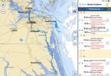
The five computer programs that we tested for this report are at, or very close to, the cutting edge of electronic charting. They all run on personal computers; all interface with a GPS to show you, pictorially, where your boat is at any time; all can do a creditable job of letting you pre-plan a cruise, and all can virtually eliminate the necessity for navigational calculation. All five use electronically scanned charts which are purchased in CD-ROM format.
None of these programs can really replace the old-fashioned paper chart, though. After all, batteries do fail and computers do crash. Electronic charting programs are best viewed as a supplement to paper charting.
What We Tested
We tested five products, representing what weve encountered in ads and at boat shows. All are designed for Windows operation. All use CD-ROM charts. All have a huge number of capabilities (logs, tides and currents, range finding, etc.); we restricted our examination to charting, which, we think, is why most people buy these programs.
Unlike programs weve seen in the past, all five units can use BBS charts (the ones produced by scanning the transparencies NOAA uses to produce their paper charts). The Jeppesen also uses its own vector charts as well as its proprietary raster charts, and all five support the commonly available chart formats. We tested all of the programs with the same BBS chart disk (on CD-ROM). Differences in chart images-on-screen and printed-were due solely to the charting program, and not the original source of the chart.
How We Tested
You can use an electronic charting program in two basic ways: as a planning tool before you go out on the water (dead reckoning, or DR, mode) and as an interactive plotter, connected to a GPS. We tried both, in planning-and taking-a short trip from Byram Harbor in Greenwich, Connecticut, to Norwalk, Connecticut. Its a trip weve made often, and its one that presents some problems to a plotting program because the course covers at least three different large-scale charts. One difference between various charting programs is how they handle the transition between two charts.
We planned our trip, noting how convenient each program was to use; we then downloaded the waypoints we had selected to our GPS, and embarked on the trip, observing how well each program did at informing us of where we were, and where we should be steering.
The computer we used-a Pentium 300 MHz model running under Windows 98-is more-or-less typical of todays laptops; while there are undoubtedly many older, less-capable computers out there, as well as newer, more-capable models, this seemed to be an appropriate machine to use.
What We Found
Taking the second mode of operation first, we didnt find a great deal of difference in how well each program reported our boats position-they all worked and worked well. In the trip-planning mode of operation, though, we found some differences in both convenience and clarity.
All of the programs have the capabilities of loading charts; printing them; scrolling from one area to another; zooming in and out to change effective chart scale; defining, modifying, and deleting waypoints and routes; examining tide and current information, and determining range and bearing between any two points on the chart. There are some big differences in how-and how well-each program handles this. Well discuss each programs advantages and disadvantages separately.
A major drawback of any electronic chart display is its size: A typical paper chart measures about 42″ x 29″, somewhat smaller with chart kits, and lets you see both a fairly comprehensive overall picture of the area and a fairly high level of detail at the same time. While presenting a much larger view than, say, a GPS plotter, an electronic charting programs display is limited to the size of the computers screen-typically a trifle under 6″ by 8″ for a laptop. If you need both detail and some sort of overview of where you want to go, frequent zooming and scrolling are required, and ease of performing these essential functions was a major factor in our ratings of these programs. Another worthwhile option is the ability to select which chart objects-cities, Aids to Navigation (ATONS, as the Coast Guard calls them), towns, latitude and longitude lines, and so on-you wish to have displayed.
A feature of many of these programs allows you to move from one chart to another seamlessly-a non-trivial trick when you consider that various charts differ both in scale and orientation. Some programs that quilt adjust the chart orientations so that they match, and display the detail level of the smaller-scale chart; others match the size and orientation of the two charts, but show more detail in the larger-scale section. We found this seamless approach (some programs call it quilting) to be an important convenience in trip planning; some programs did it better than others. And some programs that permit quilting in their screen display wont allow you to print a chart in that format.
One aspect of zooming in and out that proved particularly annoying is the fact that many programs don’t maintain the same chart center when you zoom. Another is that, if youre limited to a pre-selected set of zoom ratios, youre likely not able to fill the screen with the chart area youre concerned with.
Another nuisance factor we noted with some programs involves scrolling; some make it difficult to scroll smoothly across a large area; others present several options that let you pick the way you prefer to work, and permit a smooth transition from one place to another.
The Capn
The Capn-an acronym for Computerized American Practical Navigator-is probably the most comprehensive approach to wedding computers to navigation thats ever been attempted, at least for recreational boats. It has so many features-including celestial navigation sight reduction, inventory and maintenance record-keeping, logging, set and drift, and compass calibration-that its difficult to compare it to other, more-specialized charting programs. Nevertheless, we think that charting-electronic navigation-is probably the feature thats of most interest to most owners, and thats the aspect of The Capn that we focused on.
The Capns charting programs major drawback is its inability to quilt charts together to produce the effect of a single seamless chart that extends beyond the limits of any single chart. When you reach the end of a chart, you have to click on the adjoining blank area to open the next chart. This can be somewhat annoying when youre planning a route on-screen. It can be just as annoying when you try to print out a chart covering your planned route, particularly if its a short trip that spans several charts: You can zoom in on a large-area small-scale chart, but you wont get the detail available with the larger-scale charts. Lack of quality is not a concern when you’re out on the water. Most software producers recommend that you do real-time trip tracking on unquilted charts for better accuracy.
The quality of the Capns display and printouts is excellent. Bearing and range between waypoints is shown directly on the chart. The same information is also available, less conveniently but more legibly, in a separate pull-down window; the Capn includes a listing of ATONs, and you can pick any point on the chart and read off the bearing to the most convenient buoys or lights. You can use your cursor as an electronic ruler to determine the range and bearing between any two points on the chart. This information comes up as text in a separate window at the top of the chart.
The Capn includes tide and current tables that are displayed for any selected stations in a separate pull-down window. A thumbnail overview of an extremely large-scale chart can be displayed at the same time as a smaller-scale chart youre using to help provide a sense of general location. $495.
Nobeltec Visual Navigation Suite
Nobeltecs Visual Navigation Suite shares many of the Capns features, misses some, and adds some of its own. The most notable addition is chart quilting. If you choose, you can look at all the available charted area as if it were a single chart. Scrolling, zooming, and even printing can be performed without concern for which actual chart(s) cover the area of concern. This feature would be an extremely desirable one except for the fact that the quality of the charts produced by the Visual Navigation Suite is poor, both in display and printout. You can disable quilting, but chart quality is still poor enough to keep us from recommending the program.
This is a shame. Otherwise we liked Nobeltecs Visual Navigation Suite very much. Navigation information appears directly on the chart, and in more detail in a separate window that can be opened. Tide and current information is displayed directly on the chart (with an animated display of tide bars and current arrows). Like the Capn, Visual Navigation Suite offers a thumbnail view for orientation-Nobeltec calls it Quick View- and a nighttime view (in dim shades of red).
Unlike the Capn, which allows you to store a large number of routes by name (you pick the name) and call up only the one youre interested in at the moment, Visual Navigation Suite keeps all the routes displayed on the chart at all times. To work with one of them you simply activate it. This arrangement lets you see all the routes youve planned at the same time; it works fine if youre only dealing with a few routes, but tends to clutter the display. $489.
Nautical Software Chart View
Nautical Softwares Chart View has elected to go the quilting route, but only in its screen display. When you print out a chart, it only prints the charts that make up the quilt in a one-at-a-time mode. The quilting is as clear and as seamless as weve seen. When you scroll to a point thats covered by more than one chart, you see the maximum detail that each chart can display. When you zoom in or out, you have the choice between using a larger-scale or a smaller-scale chart.
Chart quality is excellent, both on the screen and in printouts. About the only drawback we found to using Chart View is a relatively slow (3-5 seconds with a Pentium 300 MHz machine) refresh rate when zooming or scrolling, and scrolling is slow and a bit jerky. On occasion, we found ourselves overshooting the view we were looking for.
Tides and currents are displayable either on a separate small window (as text) or directly on the chart (as bars and arrows). The chart display can be animated and displayed at various speeds, or paused for any specific time desired.
Electronic ruler measurements of range and bearing are displayed on the chart; route storage uses the same approach as Nobeltec takes. Instead of delecting a prestored route and having the program select the appropriate chart, you pick the chart and the routes youve previously planned appear on it. There are nighttime display and thumbnail capabilities, as well as an ETA calculator and an integrated log.
We found one peculiar and disturbing quirk in Chart View. When we zoomed in on the final waypoint of our trip and printed the resulting view, we found that the waypoint moved from its position just offshore of the dock area to one several hundred feet on dry land, while the route shifted so that it passed directly over (or through) an island. The waypoints and route on the monitors display didnt change, only the ones shown on the printout. We experimented a bit, and found that by adjusting the amount of zoom we could move the apparent waypoint on the printout. We checked and were told this glitch is being corrected. $495.
Jeppesen Marine Map
Jeppesen is a company thats been heavily involved with electronic charting for aircraft, which may account for some of the flavor of its interface. When you first start up Marine Map, youre presented with an outline chart covering the globe. You then use the mouse to mark off a box around the area youre interested in, and the program zooms in on that.
Jeppsens Marine Map is the only program we tested that uses both vector and raster charts. (As we were going to press, MaxSea announced it, too, can use both.) Using the program reminded us of the definite virtues of the vector chart. It can be scrolled and zoomed very rapidly, and, though it lacks the detail of a raster chart, it also is in many ways much easier to read, with much of the (often) unnecessary detail eliminated. We think that the use of vector charts, with optional raster chart overlays when detail is required, is a very practical way to go. Having said this, we must also say that the raster charts displayed by the Marine Map (except for the zoomed-in largest scale charts) arent nearly as clear and detailed as the ones produced by The Capn and Chart View.
Marine Maps quilting in its on-screen display is very good, with a couple of odd exceptions. When you try to zoom in progressively onto a smaller area, you encounter a screen display that looks like a quilt with all its stitches pulled out. Zooming either in or out gives a more reasonable view. Printouts of charts, as is the case with Chart View, consist of only the unquilted single charts, although adjoining areas with ATONS are indicated on a vector chart.
Zooming, as we noted, is odd. Scrolling is exceptionally smooth and controllable. If you zoom in past the charts resolution limits, you get a blank screen-a little unnerving at first, but a good way to prevent you from trying to read more precision into a chart than really exists.
Jeppesen lets you store previously planned routes. It has night-vision and thumbnail view capabilities, but lacks any integrated tide and current display. $379, US, $529, worldwide.
MaxSea Navigator
MaxSea Navigator, the only program of the five that can be used on either a Macintosh or a PC, struck us as a work in progress, with several nice features. We started out with the problem of sorting out the programs serial number (a hand-written Z looked exactly like a 2), endured some cryptic error messages (module not loaded), and finished up with several machine crashes.
MaxSea, which was developed by the French for ocean racers, is clearly out to make electronic charting user-friendly, and to a great extent they have succeeded. Anyone with a bit of experience with Windows or a Macintosh should have little problem getting started with Navigator. Basic operations like adding and deleting waypoints, zooming and scrolling, and looking at tides and currents are straightforward and work well, allowing you to see a seamless single chart. On the downside, the quality of the chart ranges from poor (at small-scale large-area) views to only fairly good (for large-scale views).
Some other friendly features are animated tide bars and current arrows displayed on the chart (or in a more-detailed window), and the animated course view (something like a perspective view of the highway displays featured in many GPS units). Range and bearing measurements are simple and appear on the chart, but can’t be printed. Routes can be stored, but theres no provision for a nighttime view nor a thumbnail view feature-one we find useful.
Wed like to try the next version of MaxSea to see how it will work with some bugs removed. As noted earlier, changes are being made, including the ability to use both raster and vector charts. We’ll update. $395.
Conclusions/Recommendations
Electronic charting programs, clearly, have come a long way over the past few years. We think that they still have a ways to go. After all, the electronic navigation program is but one of many ways of navigating. Its also one of the most expensive, and we think that anyone paying $400 or more for a program, plus the cost of a computer, plus the not-inconsiderable cost of a CD-ROM full of charts (we paid $180 for the set of charts covering Cape May, New Jersey to Nantucket), should have few if any inconveniences to put up with.
Of the five programs we tested, two stand out, in terms of ease of use and chart quality. The Capn does a fine job, producing excellent quality charts both in display and printed form. Its major drawbacks are its lack of quilting and its insistence on displaying almost all its printed information in separate windows, rather than directly on the chart. And, of course, The Capn has enough add-ons and features to keep a boat owner busy for a long, long time.
Jeppesens Marine Map proved to be the top performer among the programs that feature quilting. Its printouts are only of unquilted single charts, but it provides a quilted vector chart to at least suggest adjoining areas and identify ATONs in those areas-a feature we became fond of.
Dedicated chart plotters and even some handheld GPS models can, in conjunction with paper charts, perform many of the functions of these programs for less money. Paper charts are the tried and true approach, and are still a necessity even with one of these programs. All electronic chart makers issue strong statements to the effect that their programs are NOT intended to be used as substitutes for paper navigational charts; the chart printouts carry a flat statement that theyre not to be used for navigation. (We wonder, though, how many users, who after all are buying these programs for navigating, will pay attention to this warning.)
Electronic charts are not even good for eliminating the skill level and equipment required for working with paper charts; you still need the paper chart for a backup. And weve found that navigators who have become used to working with paper charts generally don’t find trip planning to be an onerous task.
What are they good for, then? Well, any one of these programs can take much of the detail work out of planning a trip and entering a lengthy series of waypoints into a GPS. They can minimize the chance of making an arithmetic error in calculating ETAs, or in converting from magnetic to true directional readings (all the programs can work with either), or in misinterpreting a tide table or current listing. And all of the programs, connected to your GPS, will present you with a clear picture of where you are at any time.
There are two other factors that are real but more difficult to put a value on. One is the pleasure that many derive from being on technologys cutting edge. When you stop to consider just what these programs are called upon to do, its somewhat amazing to see how well they do it.
And secondly, its fun to use your computer to plan a cruise, especially during the off-season when you can’t go out on the water. But don’t throw away your paper charts! These programs, as with all electronic navigating devices, are adjuncts, not replacements, for dividers, paper charts and basic navigation skills.
Contacts- The Capn, Nautical Technologies Ltd., 217 Burleigh Rd., Bangor, ME 04401; 207/942-4751. Visual Navigation Suite, Nobeltec Corp., 1505 NW Gilman Blvd., Issaquah, WA 98027; 425/961-1300. Chart View, Nautical Software Inc., 14657 SW Teal Blvd., Beaverton, OR 97007; 503/579-1414. Marine Map, Jeppesen Marine, 27370 SW 95 Ave., Wilsonville, OR 97070; 800/990-9263. MaxSea Navigator, NetSea Inc., 1600 Falmouth Rd., Centerville, MA 02632; 508/790-9797.


