


for the cruising sailor when sinking is imminent: alert rescue agencies; activate locator
beacon; protect against exposure; and launch life raft.
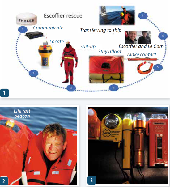
2. Escoffier’s rescuer Jean Le Cam spotted a low-wattage life raft beacon like the one
shown in the photo, an example of lights we evaluated during PS testing.
3. Some of the personal MOB lights we tested in 2019 had strobes more brilliant than
the one that led rescuers to Escoffier’s life raft.
EPIRB signal detecting satellites are part of a multinational Global Maritime Distress Safety System (GMDSS). In the US, NOAA manages and coordinates the Search and Rescue Satellite (SARSAT) program. NASA designs, builds and upgrades the technology. And the EPIRB monitoring electronics package piggybacks aboard GOES and other types of weather, communications and navigation satellites.
Over the years, a continuous effort has been made to increase the accuracy and expediency of detecting and locating broadcasts from 406MHz beacons. Last year, in the US, there were 302 rescues aided by SARSAT beacons (EPIRB, ELT, PLB). The breakdown includes 215 boaters/mariners, 75 PLB users and 12 in aviation incidents. Since its inception in 1982 COSPAS/SARSAT has aided in the rescue of over 48,000 people worldwide including 9,391 people in the United States.
Satellites are arrayed like a three layer cake. At the very top are the geosynchronous satellites (GEO), located about 22,000 miles away from the Earth. They remain constantly in view of a specific region of the Earth’s surface by revolving around the Earth in sync with its rate of rotation. This geometric relationship, results in no discernible relative motion difference between the beacon and the satellite. Therefore, position location via Doppler effect calculation is off the table.
This means that GEO satellites provide ID details of a vessel’s EPIRB , but no position information. This all changed when EPIRBS were turned into “GPIRBS,” through the addition of a GPS receiver. Now, stationary GEO satellites capture position fixes and downlink to a local user terminal (LUT) at the beacon’s location.
Low Earth Orbiting (LEO) satellites follow a circular pole-to-pole orbit, aligned about 99 degrees to the equator and at a much lower altitude (about 530 mi). They rotate around the Earth at blistering speeds and the lower altitude means a smaller circumference to their orbit—one complete rotation takes about 100 minutes. This means that any EPIRB signal entering its cone of coverage will be affected by the approach/departure based Doppler effect that causes a detectable frequency shift and can be converted into position coordinates. The downside lies in the fact that lower altitude results in a narrower cone of coverage, due to closeness to the Earth. Another downside is the need to, at times, store a signal because there’s no ground station available. This store-and-forward relay function can cause delays of many minutes, even hours, in remote oceanic regions where Local User Terminals LUTs are few and far between.
A new system, the MEOSAR satellites has been launched as part of the Global Navigation Satellite system and there was room in the trunk for a COSPAS/SARSAT electronics package. They orbit about 12,500 miles away from the earth and provide a seven times larger footprint on the surface—resolving several prior system ailments. These new satellites utilize a “bent pipe” technology that works like a mirror, continuously beaming down received signals to land based user terminals (LUTs).
When all 72 MEOSAR equipped satellites complete the constellation, there will be four satellites in view at all times. In addition, these satellites share data with each other and downlink to multiple LUTs. This means that position fixing via EPIRB, ELT or PLB distress signals can be accomplished via Doppler calculations, GPS fix or by trilateration (time-based ranging) of signals from multiple MEOSAR satellites. They eliminate the store-and-forward delay found in LEOSAR satellite technology. MEOSAR satellites that carry EPIRB detection hardware include GPS-III (USA), GLONAS-K2(Russia) and Galileo (EU). The net result is shorter fix time, faster processing and quicker rescue responses.
Once the satellite(s) does its job, ground stations spring into action. First in this rescue chain are the local user terminals (LUT) that downlink and decode the data. They determine the beacon ID from its hexadecimal code and its position before passing it along to an appropriate Mission Control Center(s) (MCC). These belong to specific nations or regions and it’s where key questions such as who will take the lead in coordinating the rescue are made. Proximity to the beacon location usually takes priority.
The MCC relays all pertinent information to a rescue coordination Center (RCC), and they determine the best means by which to effect a rescue. If the beacon is in US waters, the USCG is the RCC. In remote parts of the less developed world, where SAR assets are limited, multiple RCC centers may play a role.
In the case of Kevin Escoffier’s rescue, the RCC role was led by Race Direction located 8,000 miles away. They interfaced with France’s SAR center, Cross Griz Nez and MCC South Africa. Race Direction collaborated with weather/oceanography experts at Meteo France and provided the organizational and position guidance to the four Vendee Globe competitors involved in the search.
Feedback from those involved in the EPIRB based search for Escoffier, indicated that beacon position reports jumped around a bit. This was probably due to sea state the and fact that the small
antenna and deep wave troughs are a poor combo. However, the fixes did seem to fall within the 3.1 mile constraint of the MEOSAR goal.
Most EPIRBS are designed to be placed in the water and securely tethered to the life raft with the attached lanyard. This way the water plane acts like a massive radial improving antenna efficiency. The reluctance of someone in a life raft to toss a beacon overboard is understandable, but there are a couple of signal dampening issues that must be considered. First of all a human body situated between the beacon and the satellite will decrease the signal, so will tilting the beacon and angling the antenna away from the vertical. So if you chose to hug the beacon instead of launching it, keep the antenna vertical and above those huddled in the raft.

pole, worldwide coverage.
2. The AIS distress beacon is relatively new to the sailor’s distress alterting toolbox. It
should not be confused with the personal locator beacon.
3. Modern EPIRBs can take advantage of the newest improvements in the satellite
networks that allow for more precise position finding.