Practical Sailor likes the ability to use Navionics electronic charts, but it’s disappointing that Raytech does not support GPX data (a popular method of exchanging routes and waypoints without confusing chart datum), nor does it support freely available S-57 vector charts, the standard for government vector charts. These are both features that Practical Sailor values highly. No doubt, Raymarine’s Raytech RNS Version 6.0 has some dazzling features. But, like a lot of marine navigation programs, it is confusing to use, leading to underutilization of a great navigator’s tool.
***
288
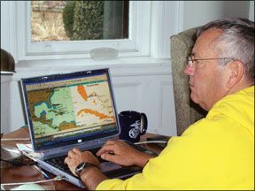
Last year, Practical Sailor looked at new versions of several popular navigation software programs (“Nav Software Wars,” September 2006). In that comparison, Maptech Chart Navigator Pro and Coastal Explorer from Rose Point Navigation Inc., came out as our top picks for Windows users. MacENC was our top pick for Apple fans. Since then, I had the opportunity to sea-trial Raymarine’s Raytech RNS Version 6.0, which offers a wide range of sophisticated features that will appeal to technophiles, but that an average boater might never need.
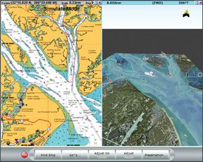
Raytech RNS Version 6.0 is an updated version of a RNS 5.0, which Practical Sailor looked at in 2005. The upgrade effectively brings RayTech RNS up to speed with the new graphic capabilities of today’s chartplotters. It also maximizes the many features—aerial photography, three-dimensional views, etc.—that are available in Navionics Platinum charts, the Practical Sailor Best Choice in 2006 (“Electronic Charts,” February 2006). The program is a logical option for anyone who uses a Raymarine SeaTalkhs network system onboard.
How We Tested
I conducted testing on a three-year-old HP Pavilion ZD7000 laptop with Microsoft Windows XP Professional Version 2002. It had a 3.06 GHz Intel Pentium 4 CPU, 768 MB of RAM, a 17-inch screen, and four USB ports running USB V. 2.0. It had all the usual input and output ports, but no serial port.
As with the most recent nav software test, my evaluation addressed these basic questions:
Does the software install quickly and easily?
Does copy protection cause awkwardness?
Does the software crash frequently, or is it reliable?
Is it obvious how to use the product for basic tasks?
Can the software product interoperate with other programs?
Can the software product interoperate with a wide variety of devices?
I also contacted tech support anonymously three times.
Most of my testing took place during a two-week delivery on a Gunboat 48 catamaran from South Africa. I also used it to carry out routing projections for Lia Ditton during her campaign in the 2006 Route du Rhum trans-Atlantic race.
Installation
During installation, there were the usual codes to input, but the loading exercise was easier than expected.
Though it’s not my usual inclination, I took the time to peruse the manual, a PDF file that comes on the disc. Browsing through the index by computer, I found that when I tried to fetch the page number listed in the index, it didn’t correspond to the topic. I had to hunt just to find the tech support telephone number, which I found buried on page 149. (The current version comes with a hard copy User’s Guide and embedded Help Topics.)
The box ships with the entire NOAA BSB raster portfolio. Loading these, or BSB raster charts you may already have (like Maptech), is pretty straightforward. You can copy your charts to a folder on your Desktop or another location that you choose. Along with Navionics, other types of vector charts such as C-Map NT+ are also supported. To our dismay, RayTech does not support the free NOAA S-57 charts, a grave omission, in our opinion.
288
When my Maptech charts were loaded, I opened RayTech, clicked “File” and “Install Charts,” and RayTech looked for any new charts on the system. New charts are detected automatically. Click “Install,” and they’re installed. You may have to wait up to an hour or so, depending on how many charts you have on your hard drive and how fast your machine is.
To interface with electronics via NMEA 0183, merely select the type of instruments you’re connecting, and the software searches for the particular data stream. The software worked just fine with my old Garmin 48 handheld running NMEA 0183. To fully experience the software’s networking abilities, you would link to Raymarine devices, like an E-Series plotter, via a Seatalkhs networking protocol.
Since this is routing software, I knew that I would need to access GRIB files, digitized weather forecast data that overlays on the charts. Again, the process went forward without any complications. I was somewhat disappointed, however, that the GRIB file option that is available for free through the RayTech website provides only three-day forecasts for specific areas of the globe. Raymarine makes longer duration files available–seven-day forecasts–but there is subscription fee of $100. There are, however, ways to get around that by using Saildocs (www.saildocs.com) to automatically retrieve GRIB files for locations that you select.
Navigation and Routing
Setting up a course and plotting a route are relatively easy tasks. Moving waypoints can be accomplished either by right clicking on the particular waypoint or clicking and dragging the waypoint to a more suitable location. You can also lock waypoints so they’re not inadvertently shifted.
There are a variety of “tools” a navigator can use. The “Ruler” will give range and bearing between any two points. “Clear Rulers,” located under the “Tools” drop-down menu, clears all “Ruler” range and bearing lines. It’s a somewhat clumsy system since you may want range and bearing lines drawn from the boat that expand, or contract over time as the boat changes position or you may have several lines drawn and only want to remove one of them.
Though this program can be used by ordinary sailors, many of the features on this software have been developed for America’s Cup campaigns. For instance, the ability to ping a mark using a laser, will be of little use to all but serious racers. The capability is there, though, if you’d like to use it—in conjunction with your laser.
One feature that beer-can sailors may not require, but which I find useful for long-distance races is “Other Boat Tracking,” located under “Tools” in the drop-down menu. You can input competitors’ times and positions, and get a great deal of useful information about how you’re doing relative to the competition. Unfortunately, learning how to use this and other sophisticated features can become a frustrating trial-and-error exercise.
Navigators never seem to have enough data easily at hand and in view. RayTech’s “Databoxes” get past that. Use their standard setup or create your own, and you’ll have whatever information you want, conveniently displayed anywhere on the computer’s screen. DataTrak is Raytech’s version of strip charts or graphs that monitor various user-
selected sets of data and how they change over time. If you’ve just changed sails and want to know if it improved performance under constantly changing conditions, watching DataTrak will tell you.
Of course, you will want to have a well-developed set of polars so that you can actually judge how you are doing compared to your optimal performance. If there is a quick way to load a particular boat’s polars, it wasn’t easy to find in the documentation. Again, I had to resort to the trial-and-error method. Monitoring engine stats is also possible with the software, but actually employing that capability requires time and effort to figure it all out.
In order to keep track of what is going on, RayTech enables a choice of multiple screen settings. Split screens that can display radar, weather, DataTrak strip charts, zoomed-in or zoomed-out, various types of charts or other combinations are conveniently available. The concept is a good one. Some of the implementation and tools could use a little refinement. For example, zooming in on charts is quick, which can be good. But the zoom is not quite smooth enough to allow the user to acquire the range he may want. First you’re in too close, and with a quick tap of the zoom button, you’re out too far. (RayTech says a mouse with a click wheel will better control zoom rate.)
Conclusion
With toolbars at the top, buttons on the right, and more buttons on the bottom, I still wasn’t comfortable after several weeks of use. It seems that a great deal of screen real-estate is inappropriately located. Most of the pop-up boxes have large pictures of smiling people racing around on powerboats, which doesn’t really add to the value of the software.
No doubt, this software has some dazzling features. But, like a lot of marine navigation programs, it is confusing to use, leading to underutilization of a great tool. Customer service was fair. A query to tech support via e-mail initially generated a slow, unhelpful response. I had better luck over the phone, but don’t expect immediate answers to tough questions.
The program was stable, and it did its job of charting and monitoring data. In fact, the more I used it, the more I appreciated it. Practical Sailor likes the ability to use Navionics charts, but it’s disappointing that Raytech does not support GPX data (a popular method of exchanging routes and waypoints without confusing chart datum), nor does it support freely available S-57 vector charts, the standard for government vector charts. These are both features that Practical Sailor values highly.
Bottom Line: If you want to maximize the power of the Raymarine network, this is your best software for you. Otherwise, Maptech Chart Navigator Pro
remains our Best Choice for Windows users, Fugawi ENC 4.0 is our Budget Buy, and Maxsea 12.0 is our Recommended software for those running Furuno NavNet network.
Bill Biewenga is a delivery skipper,
professional router, and navigation
software developer with more than 300,000 ocean miles behind him.


